|
Featured places
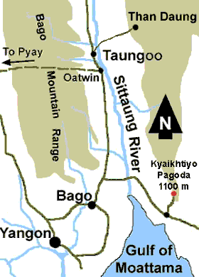
Yangon to Taungoo road map
 Yangon to Taungoo is 280 km. Up to the begining of 2003 the road was not very good and occasionally under repair in many places.
During our trip in January 2003, it took us almost 7 hours due to several sections under the remaking or repair process. Half of the narrow road was closed, and cars had to wait till the cars in the opposite direction passed away.
Yangon to Taungoo is 280 km. Up to the begining of 2003 the road was not very good and occasionally under repair in many places.
During our trip in January 2003, it took us almost 7 hours due to several sections under the remaking or repair process. Half of the narrow road was closed, and cars had to wait till the cars in the opposite direction passed away.
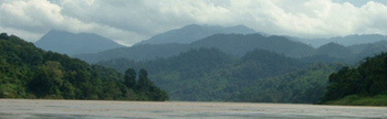
Up to Bago (80 km) you don't see any prominent hills. The highway is running north in the velley between Bago mountain range and the hills in the Kayin state on the east.
Along the foot hills of Bago range there are several logging camps. They are moving from place to place. Taungoo is a place where Timber extraction department has its regional manager office.
Between Oatwin (15 km south of Taungoo) and Pyay (on the eastern bank of the Ayeyarwaddy river - not shown on the map) there is a rough road which can be used by trucks in the dry season.
This is the only road which crosses Bago range east to west. Other smaller roads are used mainly by the villagers and the timber operators.
At 44 km north-east of Taungoo there is a scenic place called "Than Daung", inside Kayin state. There are some projects being going on there to turn the place into a hill resort. There are hills, watrefalls and river streams some of which may be good for adventure white water rafting.
Map to Taungoo |
Elephant camp |
Logging and bamboo rafting |
Myanmar Beauty guesthouse |
Back to featured places main page
|