|
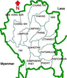
Provinces in the North
Chiang Mai
Chiang Mai city is about 761 km by railroad and approximately 700 km by car road to the north of Bangkok.
With an area of 20,107.1 square kilometers the province is Thailand's second largest province, and the capital of the
northern region. It is administratively divided into 22 districts. People can travel between Bangkok and
Chiang Mai by air flight, night bus or night train.
A large part (about 69%) of Chiang Mai is covered by mountains and hills with forests. Minority ethnic
hilltribe villages dotted many parts of the hills and thus it is famous for trekking and tribal village home stay tourism.
Waterfalls, white water rafting by inflatable rubber boat and bamboo rafts, elephant back ride are also popular out of the city
experience for both local and foreign visitors. However with the increase in such tourists activities, competition,
almost non-existence of proper participation and management by the local tribal people, and other factors
there have been reports of decreases in quality of tourist experience and authenticity as well as
cultural and environmental degradation. Being said that, it is still possible to go for a small group
simple nature walk and village homestay which is culturally, environmentally and economically
sustainable, in many hill places of the province.
Chiang Mai is also home to the country highest peak: Inthanon mountain, which stands 2,575 meters (8,448 feet)
above sea level.
Out of more than 1.5 millions people nearly 200,000 live in Chiang Mai city areas. The province is divided
into 21 districts and 2 sub-districts. 80% of the people in Chiang Mai are locals by birth, and speak a dialect
that is a slight variation of the central Thai language. The remaining 20% is made up of Thai nationals
and foreigners who have moved to Chiang Mai to work, study, or retire.
Provincial official website
Chiang Mai province - Wikipedia
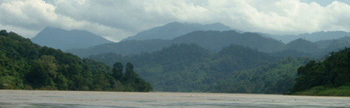
Chiang Rai
Cheang Rai is one of the oldest towns of Thailand. Its was founded in 1262 by King Mangrai. The province is located
at the northern tip of Thailand, bordering Myanmar (Burma) on the north and Laos on the east. Thai Airways
flies there daily. Bus journey from Bangko takes 11 hours. Several natural walls of high mountains
separate it from Myanmar. Mekong river and hills serve as border with Laos.
These mountain ranges are extensions of the Himalayas and some ranges
in the Chinese region of Yunnan. Nearly 90% of the whole area of Chiang Rai comprises high mountains.
Golden Triangle located 9km to the north of chiang Saen is the world famous place where the borders of Thailand,
Myanmar and Laos meet. Serveral hilltribe people live in the mountainous areas.
For long time many history text books of the world, popular media sush as movies, music, advertisement, magazines, books,
speeches, lectures, teaching, Internet, etc. have been presenting this area as something like an
origin of illicit drug and opium. However people can now study the 5000 years history of opium in the
"Hall of Opium" museum in Golden Triangle Park - a project of Mae Fah Luang foundation. The 5600 square meter
museum is located 13 km from Chiang Saen, or jusy 800 meters from the golden triangle (3 countries meeting) point.
www.maefahluang.org
(Can't find the website of Golden Triangle Park: Hall of Opium Museum - 26 Aug 2011)
As in Chiang Mai province, Chiang Rai offers nature based tourism activities: trekking and hill walking,
hilltribe village home stay, rafting and elephant riding, as well as accommodations and resorts where visitors enjoy
nice atmosphere and sceneries in modernised and modified traditional style houses or rooms.
Foreign tourists can enter Shan state (Shan province) of Myanmar from Mae Sai. Border check point can issuse
border pass to travel some areas (Tachileik, Kyaing Tone, Maung La, etc.) in Shan state of Myanmar.
At Chiang Khong one can cross the Mekong river to come to Lao's Huayxai town of Bokeo province.
Visa on arrival is available.
Nationals with visa-free privilege to Thailand can do visa run at these two borders to extend their
Thailand stay.
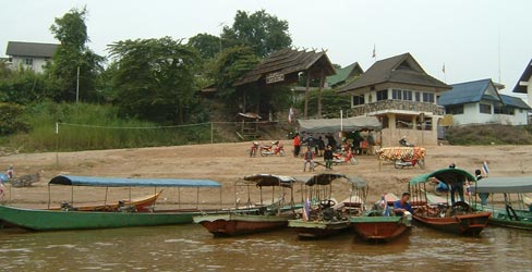
Border ferry boats on Mekong river at Chiang Khong, across Houixai in Laos
Provincial official website
Chiang Rai Province - Wikipedia
Kamphaeng Phet
Kamphaeng Phet is administratively divided into 9 districts. It is bordering with Tak and Sukhothai to the north,
Nakhon Sawan to the south, Phichit and Phitsanulok to the east, and Tak to the west. Kamphaeng Phet town is
located 358 km north of Bangkok. From Bangkok one can take a bus at Morchit New Bus terminal
(also called Morchit 2 or northern bus terminal). Western part is located in the Thailand largest Western
Forest system with forested mountains and river streams. The eastern part is largely farmland areas.
Eco nature tours, resort style vacations, and traditional sightseeing tours visiting temples, etc. are the possible
activities there.
Provincial official website
Kamphaeng Phet Province - Wikipedia
Lampang
Occupying an area of 12,533 square kilometers, Lampang is administratively divided into 13 districts. Lampang is
located some 599 Km from Bangkok. It is easily reached from nearby provinces by car and by boat.
Bangkok - Chiang Mai railroad passes Lang Phang and there is a train station at Lang Phang.
Highlights for tourists are the national parks, and hill villages, temple tours and cultural trips, farm visits, etc.
Provincial offocial website
Lampang Province - Wikipedia
Lamphun
Lamphun town is located on the bank of the Kuang river. The province is bordering with Chiang Mai to the north,
Lampang and Tak to the south, Lampang to the east, Chiang Mai and Tak to the west. Distances from Lamphun
city to the nearby places are: Chiang Mai - 21 km, Lampang - 71 kms, Tak - 244 km. It is easily accessible by
road form all nearby provinces. Lamphun is located on the Bangkok - Chiang Mai railroad.
A legend handed down from more than 1,400 years ago refers to this ancient town as Hariphunchai.
Its first ruler was Queen Chamthewi who was of Mon extraction. In late 12th century, King Mengrai overran
the town and subsequently integrated it into the Lanna Kingdom. Today, Lamphun still retains its enchanting
ambience of a small but old community. Its attractions include ancient sites and relics as well as forests and
mountains and delightful lakes. Lamphun is the most famous producer of longans. National parks such as
Doi Khun Tan national park, hilltribe villages, resort style vacation are popular.
Provincial official website
Lamphun Province - Wikipedia
Mae Hong Son
Mae Hong Son, Thailand's second northernmost province, is sheltered by several high mountains and enjoys
a cool climate almost all year round. Mae Hong Son town is located 924 km from Bangkok, and can be reached
from Chiang Mai either by highway No.108 via Mae Sariang or highway no. 1095 via Pai (northern route which is shorter).
There are daily flights between Chiang Mai and Mae Hong Son. From Bangkok people can take the night bus from
northern bus terminal, arriving Mae Hong Son in the next morning.
Maehongson is in the jungles of Northern Thailand, near the Myanmar border. This unique area surrounded by
mountains and shrouded by mists offers exciting glimpses of age-old lifestyles and traditions.
Main attractions of Maehongson are trekking to hilltribe villages, joining the exciting elephant tours, observing
the elephants at work, white water rafting in wet rainy season, caving in Phang Ma Pha district, river boating,
visiting Myanmar style temples, soaking up amids the beautiful natural surrounding.
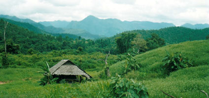
A farm hut in the hills
Provincial official website
Mae Hong Son Province - Wikipedia
Nan
A quiet and tranquil province compared to others in the north, Nan nestles in a verdant valley in northern Thailand. About 668 kilometers from
Bangkok, it covers an area of 11,472 square kilometers. Nan can be reached by road and by flight form other
major cities. On the north and north-east Nan is connected to Xarabouri, mountainous province also called the
land of elephants, in Laos. Sevral minority tribal people still live in the mountains of Nan.
Up to now (2006) the province seems to be receiving the amount of tourism which is within
cultural and environmental tolerance. Further tourism expansion are already on the way and wherther or not
these will be sustainable have yet to be seen.
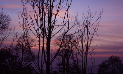
Just after sunset in Doi Phu Kha national park
Provincial official website
Nan Province - Wikipedia
Pha Yao
Phayao has an overall area of 6,355 square kilometers and is administratively divided into 7 Amphoes (districts)
and 2 King Amphoes (sub-districts): Amphoe Muang, Chun, Chiang Kham, Chiang Muan, Dok Kham Tai,
Pong, Mae Chai, King Amphoe Phu Kam Yao and King Amphoe Phu Sang. Phayao town is
located 690 km from Bangkok.
Phayao is reached by highways form nearby provinces. There are direct buses form Bangkok and many other
places to Phayao.
Provincial official website
Google map of Phayao
Phayao Province - Wikipedia
Phetchabun
Phetchabun is located in the lower northern part of Thailand, or 346 km from Bangkok. It has a total area
of 12,668.416 square kilometers. PhetchaBun town can be reached by road from anywhere, and there are
flights from Bangkok. The area is a plain dotted with many hills. The main river passing through the province
is Pasak River.
Provincial official website
Google map of Phetchabun
Phetchabun Province - Wikipedia
Phichit
Phichit is situated in the lower northern region of Thailand. The name Phichit means the beautiful town.
It was probably founded by Phraya Khot Thabong in 1056. During the Sukhothai period (1238-1350), the
community was named "Sa Luang" which was one of the important towns of Sukhothai.
Phichit occupies an area of 4,531.014 square kilometers and is located 345 km to the north of Bangkok.
Provincial official website
Phichit Province - Wikipedia
Phitsanulok
Phitsanulok province covers some 10,584.5 square kilometers. The riverside provincial capital is 377 km north
of Bangkok. Phitsanulok is situated on the geographical and administrative line uniting the central
and northern regions. Phitsanulok has long held an important political and cultural role.
Phitsanulok was the birthplace of King Naresuan the Great, one of the great heroes of Thai history,
and was the capital of Siam for a time in the 15th century. The climate of Phitsanulok is generally hot and humid.
It borders with Uttaradit in the north, Pichit in the south, Loei and Phetchabun in the east, Kamphaeng Phet
and Sukhothai in the west. Covering an area of 10,815.8 square kilometers, the province is divided into 9 districts.
Provincial official website
Phitsanulok Province - Wikipedia
Phrae
Phrae has an overall area of 6,538.6 square kilometers, and is administratively divided into 8 districts.
The city is located 555 km from Bangkok.
It is bordering with Phayao and Nan to the north, Uttaradit to the south, Nan to the east,and Lampang in the west.
Provincial official website
Phrae Province - Wikipedia
Sukhothai
Sukhothai literally means "Dawn of Happiness" - for it was the first capital of the Thais. The ruins of the ancient city
of Sukhothai have been designated a World Heritage Site by UNESCO. One can get there by road and by flight
from other cities in Thailand. At the moment Bangkok Airways fly between Sukothai and Luang Prabang in Laos too.
Tour Highlights are Sukothai historical park, Ramkhamhaeng national park, etc.
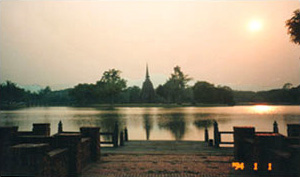
Sukhothai old city - Historical park
Provincial official website
Sukhothai Province - Wikipedia
Tak
Tak is the site of Bhumibol Dam, the largest in Thailand. Covering an area of 16,406.6 square kilometers,
Tak city is located 426 km from Bangkok, and administratively divided into 8 districts and a sub-district.
Tak is the second largest province in the north after Chiang Mai. About 70% of the areas are high mountains
with healthy forest.
The Thanon Thongchai mountain range which extends south from Chiang Mai province, passes Tak and ends
at Thong Pha Phum district in Kanchanaburi. The province of Tak is divided into two halves by this mountain range.
Mae Sot town on the Myanmar border is the place for the cross border trade. There are several
national parks, forest lands and wild life sanctuaries.
Tourist attractions are: Wat Phra Boromthat, Ancient Tak city, Bhumibol dam, Lan Sang national park, Umphang
district containing the country largest waterfall "Ti Lo Su", etc. The western side of the province along the border
is mostly in the mountains where there are many hilltribe villages. Thus nature and minority culture based
tourism for tourist wanting for experience are available.
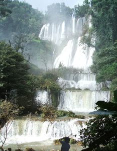
Thilorsu waterfall (said to be Thailand biggest) in Umphang - 170 km south of Mae Sot
Provincial official website
Tak Province - Wikipedia
Uttaradit
Uttaradit, located 457 km from Bangkok, is a province in the lower northern region. It is administratively
divided into 9 districts. It is bordering with Nan and Phrae in the north, Phitsanulok in the south, Phitsanulok,
Loei and the boundary of Laos (Xayabouri province) in the east, Sukhothai in the west.
Eastern part of the province is hilly and good for mountain trekking and camping. Also available are
farm or agricultural tours, boating on Sirikit dam lake, sightseeing of small town and villages culture and
life style.
Provincial official website
Uttaradit tourism
Uttaradit Province - Wikipedia
|