|
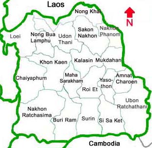
Provinces in the North-East
Amnat Charoen
Amnat Charoen is one of Thailand's newly established provinces, located 585 km from Bangkok. It was elevated into
a province on December 1,1993. It is divided into 6 districts and 1 subdistrict. People travel there by bus and by train.
Tour highlights are Phra Mongkhon Ming Muang house, Phuttha Utthayan reservoir, Chitsakon Agricultural centre,
Wat Tham Saeng Phet (a meditation sanctuary). Wat Pho Sila.
Provincial official website
Amnat Charoen Province - Wikipedia
Buriram
Buri Ram is Located 410 km from Bangkok. Buri Ram Province is divided into 21 districts and 2 sub districts.
In the past it was covered with shady trees and the land was fertile. Phanom Malai mountain range which divides
Thailand and Cambodia, lies in the province. Approximately 1.75 million rai of the area is forest land.
The main occupation here is rice farming.
Traveling to Buri Ram is possible by road and rail.
Tour Highlights are Phanom Rung historical park (Khmer architecture), Wat Khao Angkhan, Huai Talat reservoir
and birds park. Ruins of Khmer temples and Thai north-eastern farmers villages are where tourists should visit.
Prasert Hin Muang Tam (Old Khmer Temple), not far from Phanom Rung
Provincial official website
Buriram Province - Wikipedia
Chaiyaphum
Chaiyaphum province is located almost at the center of Thailand. lts size ranks third in the region and eighth in the
country. The city is located 342 km from Bangkok. Approximately 50% of Chaiyaphum is mountains and forests.
The rest is a plateau. Chaiyaphum is divided into 2 parts by the mountain range that runs through the center
of the province form east to west. The main rivers are Chi river which originates in a thick jungle in Amphoe
Nong Bua Daeng and Phrom River which comes from a jungle in Amphoe Khon San. Theese are important rivers
of the north east.
People can travel to the province by road.
Tour highlights are Tat Tone national Park, Phu Khiao wildlife reserve, Bung Waeng (a hundreds of thousands
waterfowls flock here during November through April of every year), Phu Lan Kha national park, etc.
Provincial official website
Chaiyaphum Province - Wikipedia
Kalasin
Kalasin, located 519 Km from Bangkok, is a small province with an encient area of Fa Dad Sung Yang city.
Kalasin was the city of Lava and Khom, and administratively divided into 14 districts and 4 sub districts.
It is bordering with Udon Thani, Sakon Nakhon and Nakhon Phanom to the north, Roi-Et and Maha Sarakham
to the south, Roi-Et and Mukdahan to the east, and Maha Sarakham, Khon Kaen and Udon Thani to the west.
The characteristics of the area are mountainous along the Phuphan range in the upper part while the middle
part is hilly area with the alteration of diciduous forest. Public buses leave Bangkok for Karasin daily from
northern Bus Terminal. There are no flights and trains. One may travel by train to Khonkaen and then take
a local bus to Karasin, some 77 km distance.
Tour highlights are Phra That Yakhu, Lam Phao Dam, Phu Pho, Phu Sing, etc.
Provincial official website
Kalasin Province - Wikipedia
Khon Kaen
Khon Kaen lies in the geographical heart of Thailand's sprawling northeast plateau, an area known among Thai as I-San.
Khonkaen was established in 1783 and is a major regional development centre and university city.
The provincial capital is 449 kilometres northeast of Bangkok. The province covers an area of
10,886 square kilometres, parts of which contain national and forest parks.
One can go there by bus, train, and flight.
Tour highlights are Khaen Nakhon canal, Phu Wiang national park, Ubon Rat dam, Pha Nok Khao,
Chum Phae ancient city.
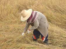
A farmer harvesting paddy (rice)
Provincial official website
Khon Kaen Province - Wikipedia
Loei
Loei is located 520 km from Bangkok, and is administratively divided into 12 districts. Loei has many things in
common with the northern region with numerous high hills, and windy and foggy climate. It is the only province in
Thailand which has the dubicous destination of the mercury plummenting to zeroºC.
One can travel to Loei by road.
Tour Highlights are Phu Kradung national park, Phu Luang wildlife sanctuary, Phu Ruea national park,
Suan Hin Pha Ngam. Basically there are many things, events and tastes to be seen and enjoyed, for example,
the traditional masked ghost
festival (Pee Tha Khon) in Dan Sai town, geography and political geography experience such as mountains and rivers,
meeting point of Mekong river and Heung river against Laos in the north, traditional unique houses in Chiang Khan on
Mekong river bank, to name a few.
Provincial official website
Loei Province - Wikipedia
Maha Sarakham
The distance to Maha Sarakham from Bangkok is 470 km. Being a rolling plain without mountain or hill with the
Chi river flowing through, the majority of the area is rice field. One can travel there by bus; or take a train or flight
to Khon Kaen and continue by bus to Maha Sarakham.
The principal occupations of Maha Sarakham people are cultivation and animal raising. Outstanding home industry
of Maha Sarakham is sericulture and silk fabric production. Maha Sarakham hand woven silk and cotton are famous
for the beautiful patterns.
Tour highlights are Phra That Na Dun, Ko Sam Phi royal park, Wat Mahachai. Best reasons to visit are focused
on the traditional rice culture and silk culture.
Provincial official website
Maha Sarakham Province - Wikipedia
Mukdahan
Mukdahan is bordering Laos to the east with the Mekong river in between. Mukdahan comprises 7 districts.
Most of the area of Mukdahan is a high plateau with dense forests in the west. The eastern part of the province
is mostly agricultural areas. The Mekong river, running 70 km along the eastern border, remains the main lifeline
of the province. One can go to Mukdahan by bus.
Mukdahan has 8 tribes of Thai people, each of which has its distinct tradition and culture. These eight tribes are
Phu T'ai, Yu, Kha, Soe, Kar Lerng, Saek, Kula, and Thai-Lao.
Tour highlights are The Pearl on the bank of the Mekong river, Phu Sa Dok Bua. Locals and foreigners can travel
cross border between Thailand and Lao's Savannakhet town by ferry boat.
A border crosing bridge over the Mekong river was opened in 2006 connecting Mukdahan and Savanakhet in Laos.
Nationals with visa-free privilege to Thailand can do visa run at this border to extend their
Thailand stay.
Provincial official website
Mukdahan Province - Wikipedia
Nakhon Phanom
Nakhon Phanom (735 km northeast of Bangkok), once the center of the ancient Sri Kotrabun Kingdom,
lies adjacent to the Mekong river. The lovely setting of the provincial capital is enhanced by the rugged beauty
of the jungled mountains which lie beyond the Laotian town of Thakaek, on the opposite bank of the river.
King Rama I selected the name Nakhon Phanom, city of mountains, because of this outstanding geographical feature.
During the centuries, Lao and other ethnic groups migrated across Maekhong River and this is reflected in
the local dialects, customs and cuisine of Nakhon Phanom.
Tour Highlights are Pra Thad Phanom, Nam Tok That Kham royal park, Renu Nakhon cultural city, border
crossing between Thailand and Lao' Thakhet (ferry boat on Mekong river), etc.
Nationals with visa-free privilege to Thailand can do visa run at this border to extend their
Thailand stay.
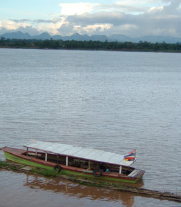
Mekong river at Nakhon Phanom - other side is Thakhet of Laos with limestone mountains, caves and rivers
Provincial official website
Nakhon Phanom Province - Wikipedia
Nakhon Ratchasima
Nakhon Ratchasima (also called Korat), the gateway to the northeast, is the Thailand's largest province.
The city is located 259 km from Bangkok. Administration of this province is divided into 26 districts and 6 sub districts.
It offers travelers high mountain ranges and dense sanctuaries. People can get there by bus and train. Korat is
a unique blend of khmer, Laotian and Thai cultures.
Tour highlights are Khao Yai national park: a favourite camping site, Phimai (Khmer) historical park, Dan Kwian ceramic
village.
Provincial official website
Nakhon Ratchasima Province - Wikipedia
Nongbualamphu
Nong Bua Lamphu (located 560 km from Bangkok) became the 76 th province of Thailand in 1993.
It is bordering with Udon Thani to the north and east, Khonkaen to the south, and Loei to the west.
Most of Nong Bua Lamphu is situated on a plateau and the province has large forested areas. There is
a long range of mountains in the northeast that level off to the west and to the southwest in Naklang and
Sriboonreung districts making these areas suitable for rice cultivation.
One can go there by bus. Another way is by train or flight to Udon Thani and then continue by bus to
Nongbua Lamphu.
Tour Highlights are Phu Khao-Phu Phan Kham national park, Phu Pha Ya historical area, etc.
Provincial official website
Nong Bua Lamphu Province - Wikipedia
Nong khai
Nong Khai is located on the right bank of the Mekhong River, opposite to Tha Dua of the Laos. It has an
average elevation of 365 meters above sea level. It is divided into 12 districts and 2 sub districts. In general
Nong Khai is part of the river basin in the north. It is a plateau with deciduous forest in the east while the west
has mountains and forest bordering forest area of Loei province. The southern area is a highland having an
average altitude of 400 meters above sea level.
There are buses and train services to Nongkhai from Bangkok. People can also take flights to Udonthani
and then take a car to come to Nongkhai.
Tour Highlights are Tha Sadet pier: the bordering pier between Thailand and Laos,
Chom Mani beach, Phu Wua wildlife reserve, border crossing between Thailand and Lao capital
Vientiane (Friendship bridge over Mekong river). Foreigners can get visa on arrival to Laos.
Nationals with visa-free privilege to Thailand can do visa run at this border to extend their
Thailand stay.
Provincial official website
Nong Khai Province - Wikipedia
Roi Et
Roi Et is the province located in the middle part of northeast Thailand, and is administratively divided into
17 districts and 2 sub districts. The city is 512 km far from Bangkok. It is bordering with Kalasin and
Mukdahan to the north, Surin and Sisaket to the south, Yasothon to the east, and Maha Sarakham to the
west. Roi Et is the large area of plateau.
One can get to Roi Et by bus and by air.
Tour Highlights are Thung Khu La Rong Hai area, Wat Burapha Phiram, Som Det Phrasi Nakharin park.
Provincial official website
Roi Et Province - Wikipedia
Sakhon Nakhon
Sakon Nakhon city is 647 km far from Bangkok. The province consists of 18 districts. Phu Phan mountain
range lies in the province. There are buses connecting Sakon Nakhon to many other places. People
can travel by train or flight to Udon Thani and continue by bus to Sakon Nakhon.
Tour highlights are Pha That Chueng Chum, Pha That Si Mong Khon, Phu Phan national park.
Provincial official website
Sakon Nakhon Province - Wikipedia
Srisaket
Si Sa Ket was originally called Muang Khu Khan. Archaeologists believe the city dates back to the time of the
Khmer empire because of the presence of many Khmer ruins. Legend has it that Muang Khu Khan used to
be called Si Nakhon Lamduan and was situated at what is now Ban Prasat Si Liam Dong Lumduan,
Tambon Tuan Yai, King Amphoe Wang Hin in the province. The town was upgraded to a city in 1759
when Ayutthaya was Thailand's capital. The first governor was Lung Kaeo Suwan who was promoted
to Phra Krai Phakdi. During the reign of His Majesty King Rama V, Muang Khu Khan was relocated to
Muang Si Sa Ket (Ban Muang Kao, Tambon Muang Nua, Amphoe Muang in the present day) but the
city still retained the name of Khu Khan until 1938 when it was renamed Si Sa Ket Province.
one can go by bus and train, and by air to Ubon Ratchatani and take the bus to Si Sa Ket.
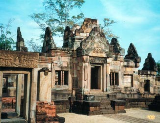
Tour highlights are Phra Sat Hin Wat Sa Kham Phaeng Yai, Khao Mo I-Dang (Khao Phra Vihan khmer temple in Cambodia),
Phrom Wihan waterfall.
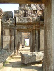
Khao Phra Vihan - Old Khmer Temple in Cambodia
Provincial official website
Sisaket Province - Wikipedia
Surin
Surin is 457 km far from Bangkok. It is bordering with Roi Et and Maha Sarakham in the north, Cambodia
in the south, Si Sa Ket in the east, and Buri Ram in the west. Surin is divided into 13 districts and 3 sub districts.
The Phanom Dong Rak mountain range demarcates surin and other provinces on Korat Plateau from
Cambodia. The plateau slopes up and then down into the valley, on which Buri Ram, Surin and
Si Sa Ket provinces are located. These provinces were once collectively called "High Cambodia"
while the adjacent low plain in present-day Cambodia was called "Low Cambodia".
Surin is connected by daily road and rail services with Bangkok and other neighbouring provinces.
Publis buses frequently leave Bangkok's northern bus terminal while train leave Bangkok many times daily.
Surin has always been influenced by the Cambodian and Thai cultures. Its strategic location in the
Thai wars against Cambodia and Vientiane made it the assembly place for elephant army during the early
Rattanakosin period.
Surin today is well known for its annual Elephant round-up, which usually takes place in the third week
of November and attracts visitors from all over the world.
Provincial official website
Surin Province - Wikipedia
Ubon Ratchathani
Ubon Ratchathani province is located in the north eastern corner of Thailand bordering Laos and Cambodia.
The approximate distance from Bangkok to Ubon by land is 629 km. The province retains a strong Buddhist
tradition, praticularly forest-dwelling monks, and distinctive folk culture which finds expression in the cuisine,
handicrafts and traditional events such as the Candle Festival in July.
This province, relatively unknown to the most tourists has cultural and historical items, rice fields, farming
villages, silk producing shops, national parks for hiking and camping, etc. In terms of geographical
environment,Ubon is the most easterly province where you can see the sunrise before anywhere else in
the country. The forestation along the Thai-Lao-Cambodian borders is the source of numerous varieties
of flora and fauna. It is also the meeting point of the three major rivers, the Mekong, Chi and Mun,
which have been Ubon's bloodlines for centuries.
Daily bus services leave Bangkok northern bus terminal (Morchit 2) for Ubon. Rapid and express train
services between Bangkok and Ubonratchathani are available. In addition, ordinary train services are
also available daily. Thai airways has daily flights.
Two groups of people constitute the demographic composition of Ubon. The first groups are
the Thai-Lao, Phu Thai, Kula, Cambodian, Suai and Blu. The new immingrants are the Chinese
and the Vietnamese.
Tour highlights are Tung Si Muang, Wat Nong Bua, Gaeng Saphue, Chong Mek Border pass
with Laos, Pha Tham national park.
Nationals with visa-free privilege to Thailand can do visa run at this Chong Mek - Vang Tao (Laos)
border to extend their Thailand stay.
Provincial official website
Ubon Ratchathani Province - Wikipedia
Udon Thani
Udon Thani is covers an area of 15,589 square kilometres. The provincial capital is 562 km northeast
of Bangkok. People can travel to Udonthani by bus, train or flight from Bangkok.
Tour Highlights are Huay Luang dam, Phu Phra Bat historical park, Phra Phuttabat Bua Ban
(there is ancient buddha footprint there), Than Ngam park.
Provincial official website
Udon Thani Province - Wikipedia
Yasothon
Yasothon is located 531 km from Bangkok. The province was made up of 6 districts
(all formerly in Ubon Ratchathani), and officially came into existence on March 1, 1972.
It is bordering with Mukdahan, Nakhon Phanom and Roi Et to the north, Srisaket to the south,
Ubon Ratchathani to the east, and Roi Et to the west.
Yasothon is a plateau and dry land. One can travel by highways.
Tour highlights are Lord Buddha foot print, Phu Thang Kwian, Chi River sand beach,
Bun Bung Fai festival (Rocket Festival) which takes place in May.
Provincial official website
Yasothon Province - Wikipedia
|