|
Nat Ma Taung (Mt. Victoria) national park - Chin state
 Nat Ma Taung (mountain) national park is located in Kanpet-let, Mindut and Matupi townships of southern Chin State.
It covers an area of 279 square miles, and is established in 1994.
Nat Ma Taung (mountain) national park is located in Kanpet-let, Mindut and Matupi townships of southern Chin State.
It covers an area of 279 square miles, and is established in 1994.
Access
Yangon to Bagan-Nyaung-Oo, 320 miles (512 km) by flight, Bagan-Nyaung-Oo to Chauk, 18 miles (29 km) by car, Chauk via Seikpyu to Hsaw, 68 miles (109 km) by car and Hsaw to Kan-pet-let, 12 miles (19 km) by car or Hsaw to Mindut, 42 miles (67 km) by car.
Objectives
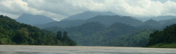
To conserve the watershed areas of Lemro river, Myitha river, Saw Chaung, Maw Chaung, Salin Chuaung, Che Chaung, Yow Chaung, Mon Chaung, etc.
To conserve the scenic beauty of natural forests.
To conserve Mountain Ecosystem and prohibit illicit hunting.
To preserve 5 species of rare birds which can be found only in Myanmar, other native and migratory birds their hbitats.
 To preserce rare species of Myanmar Orchids.
To educate local people to shif from prctising shifting cultivation to cultivating perennial plants and trees.
To promote and upgrade the park as an ecotourism attraction.
To attract tourists with water rafting and rapid-shooting during the rainy season while the river flow is rapid.
To preserce rare species of Myanmar Orchids.
To educate local people to shif from prctising shifting cultivation to cultivating perennial plants and trees.
To promote and upgrade the park as an ecotourism attraction.
To attract tourists with water rafting and rapid-shooting during the rainy season while the river flow is rapid.
Forest / vegetation types
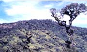
Forests inclide hill evergreen forests,
moist upper mixed deciduous forests,
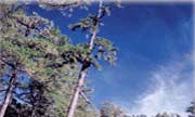
pine forests (above 9000 feet), and hill savannah.
Wildlife
Mammals such as tiger, bear, wild boar, leopard, goar, serow, gibbon, etc. and 159 bird species, reptiles and butterfly are present.
Conservation, development and research programmes
Education and prohibiting of shifting cultivation in the protected areas.
Inventory of forest flora.
Study and research on bird species and their natural habitats.
Establishment of modern Forest Village with the assistance of rule people to initiate a permanent Taungya planning system with perennial plants.
Conducting a field survey and inventory to promote and uograde the park for ecotourism industry.
Opportunities for study and recreation
Recreation and viewing of the natural mountain scenery.
Visiting the third highest Mountain in Myanmar which is (10018) feet high, and hiking a distance of 15 miles from the old Kan-pet-let city, or driving 10 miles by car from Kan-pet-let city and hiking another 5 miles to the mountain.
Observation of 159 bird speciesincluding 5 indigenous species and also Blyth's Tragopan, a very rare species.
Participation in organized Orchid Tours where the most attractive Myanmar Orchids exist.
Observing the traditional and cultural eritage of Chin pople and their living systems.
Observing the natural forest and trees, especially Rhodoendron arboreum.
Accommodation for 5 persons at the guest house.
|
Location map of parks
Khakaborazi national park
Indawgyi lake wildlife sanctuary
Chatthin wildlife sanctuary
Alaungdaw Kathapa national park
Maymyo botanical garden
Nat Ma Taung (Mt Victoria) national park
Popa mountain park
Inle lake wetland sanctuary
Shwesettaw wildlife sanctuary
Sein Ye forest camp
Moneyingyi wetland wildlife sanctuary
Myaing Hay Wun elephant camp
Hlawga park
Yangon zoological garden
Meinmahla Kyun (island) wildlife sanctuary
|
|