|
Featured places
Umphang Forest (Tak province) map and information (May 2003)
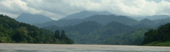
Umphang district is located in the southern tip of Tak province. The place is mostly hills, forests, river streams, caves and waterfalls.
Majority of population living there are Karen (Kayin), Thai, Shan and other minority ethnic tribes.
In the past, travelling between Mae Sot and Umphang passed places inside Myanmar (Burma). Local people lived both sides of the so-called border line.
Highway 1090 linking Mae Sot and Umphang was finished in 1990's. This 164 km winding road on the hills have more than 1200 curves. Driving time is 4 to 5 hours.
Up to May 2003, driving to Umphang via highway 1117 from Kamphaeng Phet or Nakhon Sawan is not possible.
____ Paved road
-------- Unpaved road
........... Trail
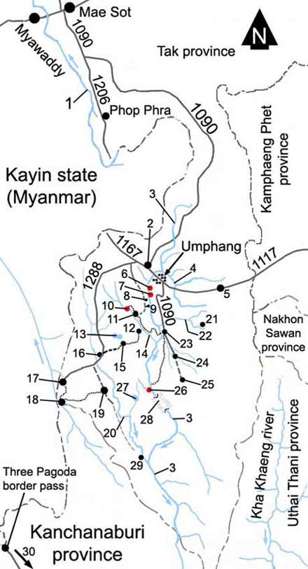 1 = Moei (Thaung Yin) river, flows into Salawen (Thanlwin) river in Mae Hong Son province. It serves as Thai-Myanmar border line. Mae Sot and Myawaddy are connected by a bridge.
2 = Mae Klong Mai village
3 = Mae Klong river stream. This river and Kha Khaeng river in Uthai Thani province flow into Si Nakharin dam lake in Kanchanaburi province. After the dam lake the river is called Kwae Yai river.
4 = Umphang river stream (flows into Mae Klong river)
5 = Umphang Ke village. Rafting trip can start in this place along Umphang river.
6 = Ti Lo Jor waterfall
7 = Hot spring (natural hot water pool)
8 = Pha Laud station (office, map, rest room)
9 = Tha Sai camp. Rafting trip to Ti Lo Su (possible whole year) usually ends here. Umphang to Tha sai on Mae Klong river is about 25 km (rafting 3 hours). From this camp to Ban Palatha by river is 15 km or 2 hours.
10 = Ti Lo Su waterfall (1.5 km from camp)
11 = Ti Lo Su waterfall camp (office, camp ground, tents for rent, rest rooms). From Umphang it is 47 km by road; the first 25 km is paved (early 2003).
12 = Ban Ko Tha (Karen village, home stay possible, small primary school). From Ti Lo Su camp it is 7 km (easy to moderate) hiking which takes 2 to 3 hours. Few houses have elephants. Vegetable growing, hand weaving.
Ban Ko Tha to Ban Palatha trail is moderate level, and is about 6.5 km or 3 hours hike.
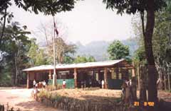 Primary school in Ban Ko Tha
13 = Lar Ee Or twin swamp (lakes in the lush forest - birds and plants). It can be reached on foot from Ti Pho Ji village.
14 = Kloh Tho river stream (which creates Ti Lo Su waterfall). The camp is on the bank of the stream. It flows into Mae Klong river.
15 = Ti Pho Ji Karen village close to the twin swamp. From Ban Ko Tha it takes 4 to 5 hours trek through forests of bamboo, hardwood and orchids. During dry season 4wd trucks can reach there from highway 1288.
16 = Ban Nu Pho Karen village can be reached by highway no. 1288 from Umphang.
17 = Pueng Klueng village (Myanmar, Shan and Thai) close to border. Myanmar name is "Pan Khan". It can be reached by car via road no. 1288.
18 = Lay Tong Ku village on the border. About 100 km from Umphang. People travel there from Pueng Klueng or Mong Kua on foot (5 to 6 hours walk - moderate to hard). Four wheels drive truck can get there in dry season.
People there do not raise pigs, ducks and chickens. However they can keep elephants, cows and buffalos. Foods include rice, fish and wild animals. They worship a pair of elephant tusks (ivory) with Buddha images curved on them.
19 = Ban Mong Kua. It is roughly 70+ km from Umphang. Four wheels drive trucks can get there in dry season. From here one can trek (passing over Khao Mong Kua mountain) 6 hours to Lay Tong Ku village.
20 = Mae Chan river stream (which later flows into Mae Klong river)
21 = Mae La Moong village
22 = Mae La Moong river stream (flows into Mae Klong river). From the two rivers meeting point ones can trek to Ban Palatha, Ban Ko Tha and Ban Ti Pho Ji.
23 = Ban Palatha village. About 27 km from Umphang. Bigger Karen village. Home stay is possible. They have bamboo houses with beddings and mosquito nets for tourists. White water rafting to Ti Lo Lay waterfall usually starts here. Elephant ride and trekking trips can be arranged.
24 = Ban Zepala village. Only 3 km from Ban Palatha. Farming rice and vegetables. The villagers also keep elephants. Women do hand weaving of cloths, clothes, bags, etc. Zepala waterfall at the end of the village.
25 = Kangae Di village. Highway no. 1090 ends here. Ban Zepala to Kaegae Di section is rough road (late 2002).
26 = Ti Lo Lay waterfall (a river stream drops into Mae Klong river from the western side). Ban Palatha to Ti Lo Lay rafting takes about 5 to 6 hours (about 40+ km). June to October (rainy season) is flooded and dangerous. November to December is the best time for most people.
January to May is low water. Camp site is located 500 meters upstream. Return journey is by elephant or walking to Ban Palatha (35 km).
27 = La Ka Toe lake. A place of deep jungles and wild animals.
28 = Nam Mood cave. Mae Klong river flows through the cave.
29 = Ban Mae Jan Tha village is located close to the meeting point of Mae Jan and Mae Klong rivers.
30 = Three pagoda border pass to Sanklaburi, Thong Pha Phum and Kanchanaburi on highway no. 323 (Kanchanaburi province).
Travel permits
The northern part of Umphang district is inside Umphang wildlife sanctuary. The lower parts are in Thungyai Naresuan wildlife sanctuary, and a small portion bordering Uthai Thani province is in Huay Kha Khaeng wildlife sanctuary.
Travel permits are necessary to enter these places. The local tour operators in Umphang would do the paper works for tourists.
Weather and roads conditions
Rainy season starts in May and ends in November, with heavy rains during July to October. From June to October the un-paved roads will be very difficult or not possible to drive. Many parts of these jungle roads would be flooded. Best months to travel are November till February, and thus places are crowded.
February to May is dry season and is good for trekking. Rafting is still possible along Mae Klong river from Umphang Ke to Tha Sai camp. The water is however low.
Drinking water and medicines
If you are hiking to far away places without car road access, carrying drinking water will be a problem. Drink only boiled water, or use good quality filter to cleanse the river water. Bring personal medicines and first aid kit.
Umphang town has district level hospital. In large villages there are nurses. Wildlife sanctuary offices have trained personnel. Be sure that you are very fit before you go adventure into the forest. Always go with a able local guide.
Ko Ko (21 May 2003)
|