|
Featured places
Hiking 1835 meters Khao Luang Peak in Nakhon Si Thammarat Province
(11 - 14 April 2005)
Although I have been to many national parks of Thailand during the past 7 years there is one in the south that I
longed to visit but missed many times because of my busy works. It is Khao Luang national park - the place of southern
Thailand's highest
peak with the same name at 1835 meters above the sea water.
This year when I received an assignment to arrange a hike for a family of four during the
songkran (Thai newyear holidays) period I knew that this was time for me to go personally.
One week before the trip I had already arranged all necessary things with the members of the
eco-tourism club of Kiriwong village at the foot of the mountain. The village is the usual starting point of
the climb. After consulting with my co-workers in the office I decided I would leave Bangkok on the 11th April
to join the climb that starts on the 12th April.
Unfortunately all the air and train tickets to Nakhon Si Thammarat were sold out and I got a seat on an evening flight to
Surat Thani on the 11th instead. I took that anyway since there was no other alternatives.
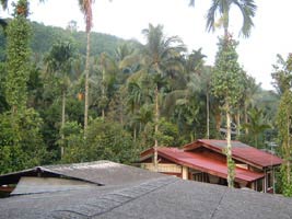
Kiriwong village (left). Begining of the trail to Khao Luang peak (right).
When my plane arrived at Surat Thanni airport just after 6 pm there was only one bus available
to Surat Thani town at 70 Baht per person. The transport company said a private salon car to Nakhon Si Thammarat would
cost a whopping 1700 Baht - much more than half of a flight ticket for Bangkok to Surat Thani.
When I was about to buy the ticket to Surat Thani one man emerged from nowhere and said he was also
going to Nakhon Si Thammarat; so we shared a private car paying 50% each.
Kiriwong villagers mostly work or work and own fruit and vegetable orchards.
They sell their firm products in raw or packed. There are some handicrafts and foods produced in the village.
During the open season, December to May, the eco-tourism club runs climbing and trekking trips using local guides.
At that night I stayed at the house of Khun O Chaiya in the middle of fruit gardens. His house is a wooden two storey
building. They gave me a bed set up with a mosquito net upstairs. The weather was just fine and I had a good sleep.
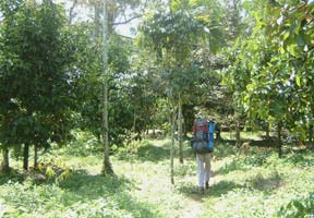
On 12 April, at 8:30 am we were ready at the trail head. There were me and four native guides. The guides would carry
all the gear such as tents and sleeping bags for the tourist family, food stuff, and cooking equipment.
They also bought several bottles of drinking water. The begining of the trail, about one and a half hour walk, was laid
with some concrete and the guides used motorbikes to carry the heavy stuff up. Just before noon we arrived at a hut
where we stopped for a swim in a nearby stream and lunch. We were still in the fruit and vegetable gardens.
After the lunch we continued, all on foot, to start the climb. About an hour later we entered the thick forest green
with many species of plants. Though it was in the middle of April, the hottest month, southern Thailand's forests
still keep their greenery with healthy looking plants and even some flowers. The trail was getting difficult but still
manageable by a novice with his full load on the shoulders.
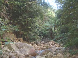
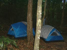
The stream at first night stop (left). Tents in early morning (right).
At about 3:30 pm we arrived a place where two streams meet and we decided to camp because of its proximity
to the running water. Beyond this point there were no place like that.
The larger stream was dry and only the smaller one that comes out of the thick of the moist forest produced some
water. We pitched the tents, collected dry woods and started to cook rice and other food. We also caught some
fishes and frogs in the stream for dinner. The shower in the stone studded stream at night was a cool experience.
The night was pleasant, neither hot nor cold, with sprinkling sound of the little waterfall nearby.
In the next moring we finished our morning business in the forest, covered them up, in different spots.
We had our breakfast of hot drink, bread, and rice, pork, fish and frogs. After packing the things up the tourists
and a guide
went ahead. The other guides cleaned the utensils, cooked lunch and followed the first party.
Today climb was steeper and we were walking through thicker forest. There were some
thorny plants on the trail, but not many. Everyone were taking care not to slip down the steep slope
by holding the branches of the trees. Occasionally we passed viewpoints where we got chance to see
outside of the lush forest we were in, as well as the frightening high wall of the mountain we are attempting.
We stopped at a couple of places to sit down and drink water.
Before noon we reached an area with a view of the outside, where we had lunch.
A little water was available at a waterfall several minutes down the place.
The next leg of the climb was the steepest, walking on the ridge laying towards the peak.
The forest was thick, the plants were green, and we could not see the sky.
So far the weather was good, no rain and the ground was mostly somewhat dry and we did not see leeches except
only one at the waterfall near the previous lunch.
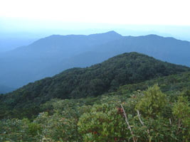
Views from Khao Luang peak looking westward
At about 2 pm we stopped again for rest at a place a few minutes walk to a waterfall.
The dishes were cleaned at the waterfall. The fall also offers a view point from where ones could
see Nakhon Si Thammarat town and the Gulf of Thailand sea.
After another one and a half hour of hike we reached to the peak.
Five minutes before the peak we visited a lesser peak with views of Nakhon Si Thammarat.
The peak provides a place for camping of up to about 15 people. Even at the peak we were still in the trees,
and had to climb to get views of surroundings. It was cool and windy. There was no water source at the peak.
The nearest water was about 6 to 7 minutes walk to a stream which emerges from a hole of underground water outlet.
The water was clear and clean. We filled up all our empty bottles.
After a delicious dinner we all crawled into the tents to sleep. It was windy, cool, yet not very cold.
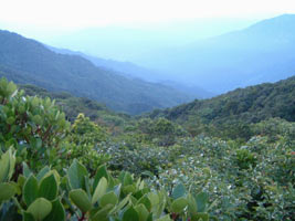
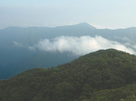 Morning view from the peak
Next day was 14 April - officially the second day of the water throwing songkran Thai newyear festival.
It was cloudy. After the breakfast and packing we headed downwards. Ascending was tired and exhausting,
yet descending gives people feeling of pain on the legs since they have to control the whole weight that falls
on them with gravity and speed. We now felt how steep the trail actually was right on the knees. We passed the same
spots and reached the first day lunch place at about 1 pm. We cooked lunch closeby the stream, had shower and
ate the last meal in the forest. Then the last section to Kiriwong village was on the easy but occasionally steep path.
Finally we reached the village at 3:30 pm.
As soon as we begun leaving Kiriwong village in a rented pick up truck we were greeted by songran revelers
with buckets full of water and water guns, ready to throw water on us.
Htut (04 May 2005)
Notes
You can contact Trek Thailand to arrange a 3 days 2 nights climb to the peak plus home stay in Kiriwong village.
Usually they will arrange local guides cum porters, all foods such as rice, meat, vegetables, hot drink and bread, and
gear for your party. Only one group per day is allowed to climb the trail due to limited camping areas as well
as to preserve the nature.
Maximum group size is 8, though 4 to 6 is the best. For a group of 4 to 6 they will arrange four local guides to carry
food and gear for the whole party. Climbing is possible from November to June.
|