|
Featured places
Climbing and camping in Ramkhamhaeng national park - Sukhothai province
(04 - 06 March 2005)
It has been more than a month since I came back from climbing Khao Luang in Ramkhamhaeng national park.
With my daily busy works in the office I did not find the time to write about the trip that also includes a brief stop-over
at old Sukhothai city. Only during Songkran (Thai newyear holidays from 13 to 15 April) I have got time to write.
We had been talking about going Ramkhamhaeng national park a couple of weeks before the trip.
I made phone calls to both
Royal Forest Department in Bangkok and the park office.
I also checked with Morchit Bus Terminal to know the bus time table.
We packed our tents, ground sheets, sleeping bags, first aid kit, other stuff such as camera, films, torch lights,
spare batteries, ropes, knife, plastic bags for garbage; and some rice, noodles, instant drink packs.
We knew that we could get a porter for 10 Baht a kilogram. But we prefered to carry things ourselves.
That meant a careful packing for a climb of 1200 meters peak - which was first time for me.
On 04 March, after lunch I went to Morchit bus terminal to make sure we got the right bus at the right time.
We wanted to arrive the park that night since we had already booked a bungalow so we could start the
climb the next morning.
The earliest bus from Bangkok to Kirimas (the closest place to the park's entrance) was a second class air-con bus
at 1530 hrs. My friend arrived at the terminal just a few minutes before the bus departure.
The bus took us through seven provinces: Ayutthaya, Angthong, Singburi, Chainat, Nakornsawan,
Pitsanuloke and Kampaengpetch before entering Sukhothai. At about 1930 hrs we arrived at Nakhon Sawan
bus station where the passengers were given 20 minutes for dinner. Only few kinds of food were available.
Although I was very hungry I could only swallowed a tasteless dish of Khao Kha Moo with water.
At 2300 hrs we got off at the Kirimas intersection and waited for the pick up car from the park, which we
had booked by phone in the morning.
From the intersection it was 15 km to the park's entrance on a paved road without street lighting. The night was cool
due to the low temperature wave coming down from China.
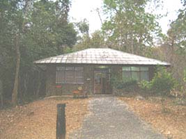
After a shower I entered into the warm bedding in the wooden bungalow house.
 In the morning of 05 March, after waiting for an hour, we were told that the restaurant would not open so we had to boil
the water in the bungalow
to make hot drink to eat with breads we had. Having only a light breakfast we headed off at 0900 hrs with all
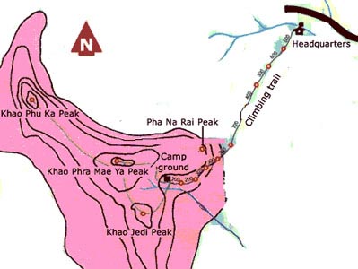
our stuff on our shoulders for the four km ascend to the mountain top camp site.
In the morning of 05 March, after waiting for an hour, we were told that the restaurant would not open so we had to boil
the water in the bungalow
to make hot drink to eat with breads we had. Having only a light breakfast we headed off at 0900 hrs with all
our stuff on our shoulders for the four km ascend to the mountain top camp site.
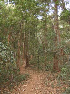
The trail was well marked and there were several rest places with wooden or bamboo benches.
Natural stream water was available at a couple of rest places.
Roughly half of the four kilometers climb was moderately steep; handrails were provided and stair steps were cut
at very steep sections for convenience.
At high elevations smokes from the recent forest fires were billowing here and there; at one point we
passed a log still burning under the flames.
After taking four hours of strains on muscles and bones on our legs and shoulders we arrived
at the camp site with empty stomachs. We had brought with us clothes, camping gear and some food
plus four large bottles of drinking water.
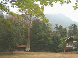
At the camp site were a small office where two staffs stationed, public toilets and shower rooms, water pipes and taps.
The camp office kept cooking equipment and tents for rent. Some dry food like instant noodles and biscuits could be
purchased.
As soon as we had our tents and things set up we started to build a fire. A pot was borrowed from the camp office for
boiling water. Dead woods were collected and fed into the fire. The strong wind knocked out the little fire and I had to
restart it again and again using small sticks and leaves. Finally we had boiled noodle soup for our late lunch.
We planned to have boiled rice lunch but it was now reserved for dinner because we were very hungry and
could not wait any longer. To tell the truth I was not sure if I could make a boiled rice smoothly in such a situation.
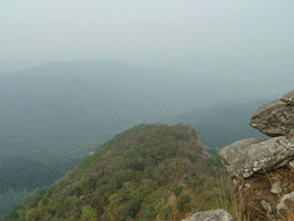
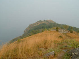
There were four mountain peaks at the top. These peaks were linked with the camp site in a circuit of trails which
were very easy to follow. We took cameras, drinking water, torch lights, paper and pencils (I like to draw scenes)
and walked to Khao Chedi peak in the south.
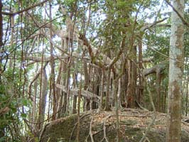
Pagoda shape stone structures were standing in the middle of burnt grassland. We continued to Khao
Phu Ka peak which was in the north-west end of the mountain. The trail took us through a lovely forest.
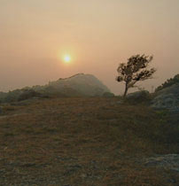
It was cloudy and windy. Before coming we did not expect cold weather in the middle of summer. However
cold waves from China had arrived just before us and now we were without warm clothings.
After spending around two hours visiting all the four peaks we came back down to the camp site to prepare dinner.
The woods we collected at the camp were now somewhat wet with the moist in the air.
We borrowed an axe from the office and cut the woods to make small sticks. It took me a long time to finish
a pot of boiled rice. The weather was cold and humid. We ate boiled rice with canned fish at 2000 hrs.
Then we cleaned ourselves and went into the tents. The night was too cold for me without warm clothings.
I used all I had to cover myself against the cold. It was a bad night with a little sleep.
In the morning of 06 March we were again using the wet wood to build fire.
We cut the woods to get smaller and dryer inner parts. We could only make a pot of boiled water
and were satisfied with hot drinks and breads as our breakfast. I washed and cleared all the stuff we used, return the
axe and pot to the camp office. After packing our tents, gear and back packs we started to go down the mountain at nearly
0900 hrs. Going down was easier and faster but it gave me more pains on my legs than going up.
Anyway we were back at the park's headquarters just after noon time. Tired, exhausted and very hungry we went
straight to the restaurant which was open to order our lunch. While waiting for the lunch I looked up the
Khao Luang mountain and saw it looked really high but I had already came back from there!
After lunch and shower at the restaurant we took a pick up truck from the park to Sukhothai
old city which we planned to visit before going back to Bangkok.
We rented bicycles and toured around the temples of Sukhothai historical park from 1400 to 1430 hrs.
We did not know the time table for Sukhothai - Bangkok bus. We hoped to get a bus at 1500 hrs if there was such a bus
so as to reach Bangkok hours before mid night. Next day was Monday and we had to get back to work.
So we left Sukhothai old city at 1430 hrs in a wooden body bus which was found to be extremely slow.
The driver was expecting passengers at every spots to fill his bus.
At the Sukhothai (new city) bus terminal we bought tickets to Bangkok in a 1700 hrs VIP bus. The bus was really fast
and we rolled into Bangkok at 2300 hrs.
Sai (17 April 2005)
|