|
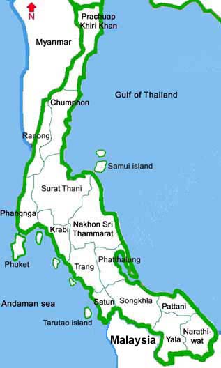
Provinces in the South
Chumphon
Following the Highway no. 4, it is approximately 463 km from Bangkok (about 476 km by railroad).
The province is divided into 8 districts. The boundary to the north is Prachuap Khiri Khan,
to the south is Surat Thani. The Gulf of Thailand sits on the east, while on the west are
the Union of Myanmar (thaninthayi division), and Ranong.
The province offers sea beaches and islands, the lowland farms dotted with small towns and
villages, and hills zip-zapped with streams under tropical forest on the border line.
Provincial official website
Chumphon Province - Wikipedia
Krabi
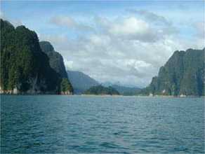
Krabi, the seaside province is located in the Andaman sea, south of Thailand. It is
administratively divided into 8 districts. The province is full of white sand beaches,
crystal clear sea water, verdant forest with caves, waterfalls, mountains, hills, plains,
and mangrove forests, and more than 130 large and small islands. There are several canals
in Krabi originating from Phanom Bencha mountain range, the highest in Krabi. There are buse
s connecting Krabi and Bangkok's southern bus terminal. Tourists can take train from Bangkok
to Nakorn Si Thammarat or Surat Thani, and then take a local bus to Krabi. Thai Airways
International operates daily services to Krabi.
Tour Highlights are Noppharat Thara beach, Fossil Shell beach, Ao Nang bay, Tham Sua cave, Huai
To waterfall, Ao Luk bay, Mu Ko Lanta national park, Laem Hang Nak cape, etc.
Provincial official website
Krabi Province - Wikipedia
Nakhonsi Thammarat
Nakhon Sri Thammarat is a southern Thai coastal province situated on the edge of the Gulf of
Thailand. Nakhon Si Thammarat is divided into 16 districts and two sub-districts.
The province is linked to Bangkok by highways, railway and air flights.
Khao Luang national park is located in this province.
There are a couple of good sea beaches.
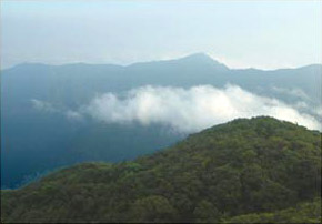
A view from 1835 meters Khao Luang mountain peak, Khao Luang national park
Provincial official website
Nakhon Si Thammarat Province - Wikipedia
Narathiwat
Narathiwat is the southernmost Thai coastal province facing the Gulf of Thailand and
bordering northeast Malaysia. The provincial capital is 1,437 km south of Bangkok by road,
and 1,116 km by train. The province covers some 4,475 square kilometers, two thirds
of which are forested mountains. The inhabitants of Narathiwat
(the name means "the residence of good people") are largely farmers and fishermen.
Narathiwat is the province having beautiful natural sceneries of both forests and
the seaside resorts. Narathiwat is divided into 12 districts.
Provincial official website
Narathiwat Province - Wikipedia
Pattani
Pattani is Located on the east coast of the Gulf of Thailand, 1,055 km from Bangkok.
Pattani is divided into 12 districts. Daily public buses link Bangkok and Pattani.
Travelling time is approximately 15 hours. There are also daily train services. It is
a small province among the five so-called southern border provines. The province is
rich in historical significance worth studying, including impressive customs and traditions,
as well as natural scenic beauty of its streams and falls, 170 km long golden beaches
along the gulf and the wonderful hospitality of the local people, all of which combine
to draw thousands of visitors to the province annually.
There are 2 seasons: summer from January to May , and rainy season from June to December.
Pattani Central Mosque, Built in the Islamic architectural style, is the venue
for praying ceremony on major Islamic days. The Saikhao waterfall national park
is located about 35 km from the provincial town of Pattani along highway no. 409.
The national park is part of the Sankalakhiri mountain range. Kaekae beach,
Panareh-chalalai beach and Wasukri beach are also beautiful sea side attractions.
Provincial official website
Pattani Province - Wikipedia
Phatthalung
Phatthalung is an ancient city in southern Thailand. It is a land of mountains.
Its town Khao Ok Thalu is clearly visible from afar. Phatthalung is regarded as the
birthplace of the shadow play and the Nora dance.
Provincial official website
Phatthalung Province - Wikipedia
Phang Nga
Phang nga occupies an area of 4,171 square kilometers. The town is 788 km from Bangkok.
It is bordering Ranong and Surat Thani to the north, Surat Thani and Krabi to the east ,
Phuket and Andaman Sea to the south, and Andaman Sea to the west. Phangnga is
administratively divided into 8 districts. There are daily buses linking it and
Bangkok's southern bus terminal. People can take flight to Phuket and continue by
road for another 58 km. Major geographical characteristics are forests and mountains.
Tour highlights are Wat Narainikaram situated at Tambjon Le, some 14 km from Ka Pong
district, Mu Koh Similan and Mu Koh Surin marine national parks, etc.
Provincial official website
Phang Nga Province - Wikipedia
Phuket
Phuket is known as the Pearl of the Andaman. Phuket is a large island in the Indian ocean,
connected to Thailand's mainland by bridges. Its beautiful beaches and forested hillsides
help give phuket the lovely character that keeps visitors flocking from around the globe.
To get to Phuket one can go by air, sea,and road. There are several domestic and international
flights to Phuket.
Provincial official website
Phuket Province - Wikipedia
Prachuap Khirikhan
Prachuap Khirikhan is located some 281km South of Bangkok. It is divided in to 7 districts
and a sub-district. It is bordering Phetchaburi to the north, Chumporn to the south, Gulf
of Thailand to the east, and The Union of Myanmar to the west. Prachop Kirikhan is the land
of beaches and mountains. From Bangkok, drive for about 3 hours along the Highway
35 (Thon Buri-Pak Thao route) via Samut Songkhram then turn left to the highway no. 4.
Tour Highlights are Hua Hin sea beach, Klai Kangwon palace, Namtok Pa La-u, Sam Roi Yot
national park, Khao Chong Krachok or Mirror Mount.
Provincial official website
Prachuap Khiri Khan Province - Wikipedia
Ranong
Ranong is situated in the Kra Isthmus facing Indian ocean. It is Thailand's least populated
province. Ranong borders the Union of Myanmar at Victoria Point, a village famous
for Burmese gems and other local products.
Ranong covers an area of 3,298 square kilometers and is divided into 4 districts
and a sub district. Ranong is 568 km south of Bangkok, and can be reached by bus and air.
Tourist attraction are Hot springs, Namtok Punyaban, Namtok Ngao, Hat Chan Damri,
Victoria Point, Ko Phayam, Namtok Chum Saeng or Namtok Sai Rung, Isthmus of Kra, Namtok
Bokkrai, Khao Fa Chi, Laem Son national park, Namtok Khao Phra Narai, and Khlong
Nakha wildlife sanctuary.
Tourists can take ferry boat to Myanmar's Kaw Thaung town by paying a border pass fee.
People of some nationalities who can enter Thailand visa-free can do visa run to extend
their stay in Thailand.
Provincial official website
Google map of Ranong
Ranong Province - Wikipedia
Satun
Satun is a province in the South of Thailand that borders Malaysia. It is situated
on the west coast in the vicinity of the Straits of Malacca in the Indian Ocean.
Satun is about 973 km from Bangkok. Its total area of 2,478.98 square kilometers
encompasses 105 islands at sea.
Beautiful Taruto marine national park is located in the province.
Provincial official website
Satun Province - Wikipedia
Songkhla
Songkhla covers an area of 7,393.9 square kilometers. It is divided into
16 administrative districts. Songkhla has been dubbed "the great city of two seas".
It overlooks Lake Songkhla (the inland sea or Thale Nai as local people call it) on
the west and the Gulf of Thailand (the outer sea or Thale Nok as local people call it)
on the east. Histoeically, Songkhla has been free commercial port and is home to a large
community of overseas Chinese. Buses run daily between Bangkok and Songkhla (13 hrs drive).
There are daily trains and flights from Bangkok to Hat Yai.
Among the attractions is the city's most famous Nam Tok Ton Nga Chang (Elephant Tusk)
waterfall which cascades down a steep cliff. Hat Yai (the shopping city) offers many
good buys in Thai handicrafts - especially local cotton products, leisure and sportswear.
Also a large variety of preserved thai fruits, dried seafood and other culinary delicacies
are available here.
Provincial official website
Songkhla Province - Wikipedia
Suratthani
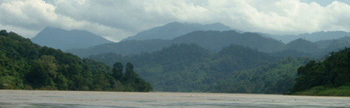
Surat thani is the biggest province in Thailand's southern region. Its diverse
geographical features include mountains, plains, rivers, coastlines, and hundreds
of archipelagos. The moist tropical forest in Phuket range in the west and in Nakhon
Si Thammarat range in the east nourish diverse fauna, flora and wildlife, including
precious trees, fruit trees, vegetables and herbs. Fourteen rivers originating from
this province give it the name "the city of rivers".
The rain forest of Khao Sok national park, Koh Angthong marine national parks are
located in this province.
Cheow Lan dam lake, Khao Sok national park, Surat Thani province
Provincial official website
Surat Thani Province - Wikipedia
Trang
Trang is a coastal province on the Indian Ocean with a long western coastline
of about 199 km. The province consists of an archipelago in the Andaman Sea with
over 46 islands. The best time for sea travel is during October to May. Trang has
a total area of 4,941.439 square kilometers and is divided into 9 districts
and 1 sub-district. The important Trang river flows through the province from
its origin in the Khao Luang mountain range.
Provincial official website
Trang Province - Wikipedia
Yala
"A beautiful border town, southernmost in Siam" is the slogan of Yala province.
The word "Yala" comes from a folk word "yalor", meaning "fishing net" because at
the original site of the town, Yalor, there was a mountain shaped like a fishing net.
It was a low land and people earned their living by using fishing nets to catch fish.
Eventually, many new towns were set up one after another until finally it moved to Nibong,
which is its present location. (Nibong means a kind of tree called "laocha-on").
Yala is the southern most province of Thailand with and area of 4,521 square kilometres.
It is 1,055 km from Bangkok by rail and 1,440 km by road. It is the only one
southern province that is not next to the sea. Yala is mostly mountains and
covered with forests but has very little flat land.
Provincial official website
Yala Province - Wikipedia
|