|
Provinces in the Central
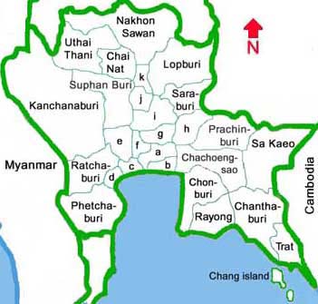 a = Bangkok
b = Samut Prakan
c = Samut Sakhon
d = Samut Songkhram
e = Nakhon Pathom
f = Nonthaburi
g = Pathum Thani
h = Nakhon Nakyok
i = Ayutthaya
j = Ang Thong
k = Singburi
|
Angthong
Ang thong is a small province in the upper Chaopraya river basin. The town is located 105 km north of Bangkok. Angthong is administratively divided into 7 districts. Almost all of the province area is low plain with little forests and hills. There are two important rivers: the Chao Phraya river and the Noi river.
There are air and non air-conditioned buses linking Ang thong and northern bus Terminal in Bangkok. Interesting places are Wat Chai Yo Woramaha Wihan, Bang Sadet village, Wat Pha Mok Worawihan.
Provincial official website
Ang Thong Province - Wikipedia
Ayutthaya
Phra Nakhon Si Ayutthaya (also called Ayutthaya) had been a Thai capital for 417 years. Many ancient ruins and art works are seen in a city that was founded in 1350 by King U-Thong. During the period that Ayutthaya was the Thai capital,33 kings of 5 dynasties ruled the kingdom until it was destroyed by Myanmar soldiers in 1767. Ayutthaya is located 76 km north of Bangkok and boasts magnificent ruins. Both air and non air-conditioned buses leave Bangkok for Ayutthaya daily and there are trains going directly to Aayutthaya every 50 min from Hualampong Railway Station in Bangkok. Another way to go to Ayutthaya is by boat on Chao Phara river. The ancient city of Ayuthaya is located on an island in the Chao Phraya River, about 80kms north of Bangkok. Ayuthaya's scattered temples and ruins have been declared as a World Heritage Site.
Places to visit are Grand Palaec or also called Ancient Palace, Bang Pa-in summer palace, Phra Thinang Aisawan Thiphya-art, Wihan Phra Mongkhon Bophit, Ayutthaya Historical Study, Royal Folk Arts and Crafts Centre At Bang Sai, Wat Phananchoeng.
Provincial official website
Phra Nakhon Si Ayutthaya Province - Wikipedia
Bangkok
Bangkok is one of the most vibrant capitals of south-east Asia. Thais call it "Krung Thep" meaning the city of angels. It is considered one of the biggest cities in the world.
Bangkok occupies a total area of 1,568 square kilometers. It is situated on a flat plain divided by the Chao Phraya River. Composed of about 50 districts (Khets), it is home to one-tenth of the country's population. Thon Buri, a former capital, is now a district under the administration of the Bangkok Metropolis. Public buses are plentiful and cheap, with a minimum fare of 3.5 baht to most destinations. Airconditioned blue buses have minimum and maximum fares of 6 and 16 baht respectively. Orange airconditioned buses charge 8 to 18 baht. Airconditioned microbuses charge a flat fare of 20 or 25 baht all routes. A bus route map can be obtained at bookshops and the tourist offices situated at city's popular spots.
The soaring roofs and gleaming spires of the Grand Palace and the city�s many historic temples � Temple of the Emerald Buddha, Temple of Dawn and other shrines � present the visitor with a picture of medieval oriental wonder.
Provincial official website
Bangkok - Wikipedia
Chachoengsao
Chachoengsao is located to the south of Phrachinburi and Nakhonnayok, to the north of Chonburi and Chantaburi, to the east of Samut Phakan and Bangkok, and to the west of Sakaew. The provincial capital is 82 km from Bangkok. It is divided into 10 districts and a sub district. General area of Chachoengsao is low flat and low plain river. The area close to the sea is mangrove forest. The eastern area in Amphoe Sanamchaiket has high and steep spots and hills as high as more than 300 meters.
Chachoengsao is connected by daily road and rail services with Bangkok. Air and non air-conditioned coaches frequently leave Bangkok's northern bus Terminal and Ekamai station (eastern bus terminal) throughout the day for an hour journey while train leave the Hualampong (central) railway station many times daily for Chachoengsao.
Interesting places are Wat Sothon Wararam Woravihan, Wat Pho Bang Cla Fruit Bat, Khao Hin Son development study center, Hin Son hill. Currently the new Bangkok international airport is being built.
Provincial official website
Chachoengsao Province - Wikipedia
Chai Nat
Chai Nat is 194 km north of Bangkok, and is administratively divided into 6 districts and a sub district. It borders Nakhon Sawan and Uthai Thani to the north, Suphan Buri to the south, Nakhon Sawan and Sing Buri to the east, and Suphan Buri and Uthai Thani to the west. Both air and non-airconditioned buses leave Bangkok's northewrn bus terminal for Chai Nat for the 2.5 hours journey.
Tour Highlights are Chao Phraya dam, Chai Nat bird park, Wat Pak Khlong Makham Thao, etc.
Provincial official website
Chainat Province - Wikipedia
Chanthaburi
Chanthaburi is located about 245 km from Bangkok and 110 kilometers from Rayong. Chanthaburi, commonly called Muang Chan, is another major eastern seaside province. The climate is tropical. Generally warm and humid with abundant rainfall of more than 6 months. The best months to travel are November through February.
Tour Highlights are Jewelry street, Khao Soi Daw wildlife reserve, Khao Khitchakhut national park, Namtok Phriew national park, etc.
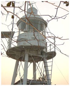
Laem Sing lighthouse overlooking Gulf of Thailand, in Chanthaburi
Provincial official website
Chanthaburi Province - Wikipedia
Chonburi
Chonburi, located 81 km south-east of Bangkok, is divided into 9 districts. It is bordering with Chachoengsao to the north, Chanthaburi to the east, Rayong to the south, and Pattaya Bay to the west. General area of Chonburi is low land, seas beaches, and islands.
There are buses leaving Bangkok several times daily from Ekamai (eastern bus terminal) and Mochit 2 (northern bus terminal), and there is one daily train service between Bangkok and Pattaya.
Tour Highlights are Pattaya beach, Theme and amusement parks, Wat Yai Indraram, the Institute of Marine Science, Nong Mon local market, Khao Khieo open zoo, mini siam park, Chantathen waterfall, Ang Sila beach, Khao Sam Muk, Bang Saen Beach, Chomtien Beach, The Million Years stone park, Chang island, etc.
Provincial official website
Chonburi Province - Wikipedia
Kanchanaburi
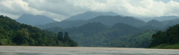
Kanchanaburi is a large province located 129 km to the north-west of Bangkok. It is bordering Myanmar (Burma) in the west and north, Ratchaburi and Nakhon Phratom to the south, and Suphanburi to the east. It consists of 13 districts. Kanchanaburi is one of the most beautiful provinces of Thailand with a mountainous landscape. The province is connected to Bangkok by railway and 4-lane highway no. 323. There are serveral hilltribes such as Thais, Mons and Karens living in the villages.
Tour Highlights are Bridge over the river Kwai, War cemetry, Sai Yok waterfall, Thung Yai Naresuan wildlife reserve, Sai york national park, Erawan national park, and the westernmost district of Sangklaburi town (at Myanmar border) and its "Mon" culture.
Tourists can enter Myanmar for a day return trip by paying a border pass fee.
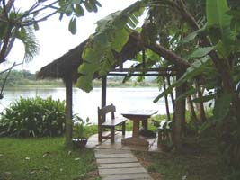
A nice place to stay on an island on Mae Klong river, close to Kanchanaburi town
Provincial official website
Kanchanaburi Province - Wikipedia
Lobburi
Lobburi today is a modern garrison town with the provincial capital located 153 km north of Bangkok. Lobburi consists 21 districts. One can get to Lobburi by bus and train.
Tour Highlights are Phra Kan shrine, Phra Phrang Sam Yod, Sun flower Field.
Provincial official website
Lopburi Province - Wikipedia
Nakhon Phathom
Nakhon Pathom is located in an alluvial plain in the central region, about 58 km by road from Bangkok. It is divided into 7 districts. Generally, it is an area of alluvial plain which is drained by the Tha Chin River. One can go there by train and bus.
Interesting places are Phra Pathom Chedi and Dhammacakra (Symbol of the completeness of the Dhamma), Thai Waxy Model Museum, Buddhamonthon.
Provincial official website
Nakhon Pathom Province - Wikipedia
Nakhon Nayok
Nakhon Nayok is 106 km north of Bangkok by the highway following Khlong (canal) Rangsit. Nakhon Nayok province consists 4 districts. Much of it is forested hillsides -- some form parts of national parks laced with waterfalls, and others are lavishly landscaped botanical gardens. There are many buses to Nakhon Nayok.
Tour Highlights are Ban Donglakhon ancient city, Wong Trakrai, Sarika waterfall, Nang Rong waterfall, as well as
forest nature trails in south-western part of Khao Yai national park.
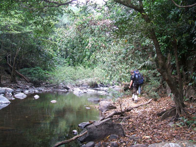
Trekking the trail along Nang Rong creek in Khao Yai national park
Provincial official website
Nakhon Nayok Province - Wikipedia
Nakhon Sawan
Nakhon Sawan is where major rivers converge to from Chao Phraya river. Nako Sawan is located 294 km to the north of Bangkok. One can travel by motor road to there. It is bordering with Kamphaengphet in the north, Chainat and Uthai Thani in the south, Phetchabun and Lopburi in the east, and Tak and Uthai Thani in the west.
Provincial official website
Nakhon Sawan Province - Wikipedia
Nonthaburi
Nonthaburi, only 20 km far from Bangkok, consists 6 districts. It is accessible by roads.
Tour highlights are Wat Chaloem Phra Kiat, Joe Louis Theatre, Ko kret island of pottery, etc.
Provincial official website
Nonthaburi Province - Wikipedia
Phetchaburi
Petchburi province is located to the south of Ratchaburi, to the north of Prachuap Khirikhan, to the east of Myanmar's Thaninthayi province, and to the west of Gulf of Thailand. Phetburi town is 123 km to the south-west of Bangkok. It is administratively divided into 8 districts. The western part is forested moutains. The eastern part is the combination of plain-land, limestone-hills, caves and sea beaches. From Bangkok, one can take the bus (about 2 hours), or train travelling to Phetchaburi.
Tour Highlights are Phra Ratchanives Phranakhon Khiri, Kaeng Krachan national park, Cha-am beach.
Provincial official website
Phetchaburi Province - Wikipedia
Prachinburi
Prachinburi town is 135 km from Bangkok. Phrachinburi is divided into 7 districts. One can take bus or train to Prachinburi.
Tour Highlights are Wat Thon Po Simahapho, Wat Kaew Phichit, Khao E-To waterfall and Chakkrapong dam. There are some eco tourism lodges and resorts there, offering white water rafting in the rainy season (June till Dec), camping and trekking, etc.
Provincial official website
Prachinburi Province - Wikipedia
Pathum Thani
Pathum Thani is a neighbouring province of Bangkok. Pathumthani Town is only 46 km from Bangkok. It is administratively divided into 7 districts. The north stretches to Saraburi, the south stretches to Bangkok and Nonthaburi, the east stretches to Nakhonnayok and Chachoengsao, and the west stretches to Ayutthaya. It is in the Chao Phraya river basin with plenty of canals and orange plantations.
It was the settlement for the Mon people migrating from Mothama (in Myanmar) over 350 years ago. It is accessible by various buses and trains.
Tour Highlights are National institute of memory, Shell Pagoda Temple or Wat Chedi Hoi, City Central Shrine.
Provincial official website
Pathum Thani Province - Wikipedia
Ratchaburi
This province, located 100 km from Bangkok, is divided into 9 districts. The north stretches to Kanchanaburi, the south stretches to Phetburi, the east stretches to Samutsakhon-Samutsongkhram-Nakhonphathom, and the west stretches to Myanmar. Ratchaburi has a varied topography: from the fertile level ground around the basin of the Mae Klong River where the economy relies on all kinds of crop, vegetable and plant cultivation, to the high mountain ranges of the Tanawsri in the west, along the Thai-Myanmar border. One can go there by bus and train.
Tour highlights are Damnoen Saduak floating market, Khao Bin cave, Hot Water stream.
Provincial official website
Ratchaburi Province - Wikipedia
Rayong
Rayong is located on the east coast of Thailand on the northern shoreline of the Gulf of Thailand, about 179 km from Bangkok. It is divided into 6 administrative districts and 2 sub-districts. In general the geography of Rayong is marked by a series of mountains interspersed by flat plains and large tracts of land under forest, rubber and fruit plantation. The climate is tropical, generally warm and humid with abundant rainfall. The best months to travel are November through February. One can go by bus to Rayong.
Tour Highlights are King Taksin Shrine, Sunthonphu Monument, Laem Charoen and Sang Chan beaches, Khao Lamya-Mu Ko Samet national park, Khao Chamuang-Khao Wong national park.
Provincial official website
Rayong Province - Wikipedia
Sa Kaeo
Sa Kaeo is a newly established province upgraded from Amphoe Sakaeo of Prachinburi Province in 1993. Sakaeo is an eastern boundary province, located 220 km from Bangkok. It is administratively divided into 7 districts. It is bordered by Buriram in the north, Chantha Buri in the south, the Kingdom of Cambodia in the east, and Chachoengsao-Prachinburi in the west. People can take a bus to Sakaew.
It has a border passing point with Cambodia at Aranya Prethet town.
Tour highlights are Sra Kaew-Sra Khwan, Pang Sida national park, Khao Chakan,
Ban Clong Luk border market.
Citizens of some countries who are granted "visa-free" visit to Thailand can visa run
at Aranya Prathep - Poi Pet (cambodia) border to extend their Thailand stay.
Provincial official website
Sa Kaeo Province - Wikipedia
Samut Prakan
Samutprakarn province widely know as "Muang Pak Nam" is located at the mouth of the Chao Phraya river, north to the Gulf of Thailand and 25 km from Bangkok. The whole area covers 1,004 square kilometers of alluvial plain, crisscrossed by canals, causing some areas flooded. Most of the area is covered with paddy fields and orchards, with groves of Samae (a small tree of the family Myrsinaceae), prong (a plant of the genus Cycas), the mangrove and nipa palms. Well known goods from this province are �Khanom Chak� or sweetened sticky rice wrapped by nipa palm leaves and dried gourami. The administration of Samutprakarn Province is divided into 5 districts.
Provincial official website
Samut Prakan Province - Wikipedia
Samut Sakhon
Samut Sakhon was formerly called "Tha Chin" probably because, in the old days, it had been a trading port dealing with a vast number of Chinese junks. In 1548, a town named "Sakhon Buri" was established at the mouth of the Tha Chin River. It was a centre for recruiting troops from various seaside towns. The name of the town was changed into "Mahachai" when Khlong (canal) Mahachai was dug in 1704 to join the Tha Chin river and the town. Later, the town was renamed "Samut Sakhon" by King Rama IV but it is still popularly called "Mahachai" by the villagers. Samut Sakhon occupies a total area of 872 square kilometres and is administratively divided into 3 districts: Muang Samut Sakhon, Krathum Baen, and Ban Phaeo. It is a major fishing port and also the biggest producer of brine salt.
Provincial official website
Samut Sakhon Province - Wikipedia
Samut Songkhram
Samut Songkhram, a coastal province at the mouth of the Mae Klong river, is 63 km south-west of Bangkok along Highway No. 35. It occupies an area of 416 square kilometers and is administratively divided into 3 districts (Amphoes): Muang Samut Songkhram (locally called Mae Klong), Amphawa, and Bang Khonthi. The area is a low land with many canals. The people cultivate various kinds of fruits such as grapes, lychee, pomelo, guava and coconuts.
Provincial official website
Samut Songkhram Province - Wikipedia
Saraburi
Saraburi, a province in the upper central region of Thailand is rich in tourist attraction including natural sites, artifacts, festivals,temples as well as historical sites.It is located 108 km north of Bangkok and 65 km from Ayutthaya. Topographically the southern and western parts of Saraburi are plateaus 2 meters above sea level. Ranging from plains to plateaus of 8 to10 meters high above sea level broken by mounds and hills, the land gradually rises to the north and the northeast. Saraburi is on the very important river: the Pasak River which flows through Amphoe Muak - lek, Kaengkhoi, Muang Saraburi and Saohai and meets the Chao Phraya river in Ayutthaya. Saraburi extends over an area of 3,576.48 square kilometres and is administratively divided into 11 districts.
Provincial official website
Saraburi Province - Wikipedia
Singburi
Sing Buri is an interesting town situated 142 km north of Bangkok, and was probably founded in pre-historical period. In the reign of King Rama V, three small towns: Sing Buri, In Buri and Phrom Buri, were combined and established as a new town on the west of the Chao Phraya river and named as Sing buri. Sing Buri occupies an area of 841.40 square kilometers and is administratively divided into 6 districts: Muang Sing Buri, In Buri, Bang Rachan, Khai Bang Rachan, Phrom Buri and Tha Chang.
Provincial official website
Sing Buri Province - Wikipedia
Suphan Buri
Suphan Buri was formerly called Phanthum Buri. It was constructed during the year 877-882 A.D. on the left bank of Tha Chin river in the vicinity of Tambon RuaYai adjacent to Tambon Phihan Daeng. When the Phanthum era was over, King Katae (half Thai half Mon) was crowned and after ascending to the throne he commanded the town to be moved to the right bank of Tha Chin river, to construct Wat Sanam Chai and to restore Wat Pa Lelai. He then persuaded 2,000 officials to enter the monkhood. The name of the town was then changed to be Song Phan Buri (city of two thousands). Later on, King U Thong moved the location to the southern bank (west of Tha Chin river). The city was given a new name as U Thong until the reign of King Khun Luang Pha Ngua when the name was changed to Suphanburi. Suphanburi had been an important border town involving battles and wars. These caused regular damage through all ages in the past until the Ratanakosin era during the reign of King Rama VI. Then the Suphanburi communities were consolidated and settled down on the east bank of the Tha River (Suphan River) as it is now.
Suphanburi, located some 169 kilometers from Bangkok, occupies an area of 5,358 square kilometers and is adminstratively divided into 10 districts.
Provincial official website
Suphan Buri Province - Wikipedia
Trat
Situated on the eastern border of Thailand, Trat is 315 km to the south east of Bangkok.
The province occupies the area of 2,819 square kilometers or 1,761,875 rai.
In the province there are 5 districts namely Muang, Khao Saming, Laem Ngob, Klong Yai,
Bo Rai and 2 sub-districts: Koh Kud and Koh Chang islands.
The province is close to Chantha Buri and Cambodia in the north and adjacent to the Gulf
of Thailand in the south. On the east it is separated from Cambodia by Buntud Mount mountain
range eastwards from the middle of the province. Weru river seperates the west Trat from
Chantha Buri. Koh Chang island is the ideal location for the vacations as the weather there
is very comfortable with the average temperature not too cold or too hot. Koh Chang is
influenced by the north-eastern and south-western storms. That triggers limitations to
the water transportation to the group of islands. Between May and October which is
the period of south-western monsoons, the west coast is always visited by storms
and thus, not safe for ferry boats. Between November to April is safe since there
are quite a few storms.
Most of Trat areas lie in the Gulf of Thailand. This makes the province abundant
with tourism resources. Trat has as many as 52 islands including Koh Chang, and
waterfalls, river streams and forests. The province is also the source of red sapphire,
fine shrimp paste and sweet rakum, a kind of palm of genus Zalacca with
sweet and acid taste.
Passport holders of some nations who are granted "visa-free" visit to Thailand can do visa run at
Klong Yai - Koh Kong (Cambodia) border to extend their Thailand stay.
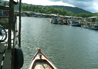
A fishing village in Trat
Provincial official website
Trat Province - Wikipedia
Uthai Thani
Recent excavations have indicated that this area was inhabited by prehistoric people.
There are several tourist attractions and places of interst but because the township
area is far from the main highway few visitors make the trip to this interesting province.
Uthai Thani occupies a total area of 6,730 square kilometers, and is located 219 km north
of Bangkok. It is divided into 8 districts.
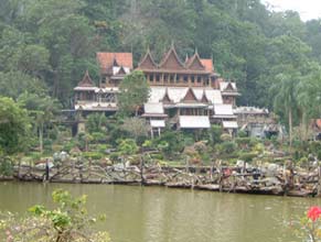
Khao Wong Temple Monastery in Ban Rai district, Uthai Thani province
Provincial official website
Uthai Thani Province - Wikipedia
|