|
National parks in the North
Doi Inthanon National Park
Click to go to the map
Topography and climate
Historically, the mountain of Doi Inthanon was refered to as Doi Ang Kha. Prince Intharawichayanon, the last ruler of Chiang Mai, realized the importance of the country's forests especially those in the north where they serve as the sources of headwaters for much of the country. He helped support people to study the areas. He requested that his remains be placed on the summit of Doi Ang Kha. After his death, the mountain was renamed Inthanon, a shorten version of his name. Today, visitors to the summit can see the remains of the prince there.
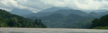
The Park is ruggedly mountainous. Doi Intanon, the highest peak stands at 2,565 meters above sea level. Lesser peaks include Doi Hua Luang (2,330 meters). The park is the source of headwaters for the Mae Klang, Mae Pako, Mae Pawn, Mae Ya, Mae Cham and Mae Khan rivers. The water from the park helps generate electricity at the Bhumipol dam site in Tak province.
Because of the park's high altitude, the climate is cool all year round. January is the coldest month with an average temperature of 5.5ºC. Even in the hot season (March to June) the temperature remains pleasant, particularly at higher elevations. Rain, fog and mist can obscure the view for days.
Forests
The forest of the park is one of the country's most important heritages. Forest types include moist evergreen forest, pine forest and mixed decidousus species with economic value including teak, mountain pine, etc. In addition there are many beautiful flowers including vanda, phycastylis and rhododendron. Mosses such as sphagnum and osmanda are found at higher elevations. There are Royal Projects, assisting the villagers grow cold-climate fruit such as strawberries, grapes and apples as well as flowers in the park. The number of wild animals in the park is decreasing due to hunting, farming and tourism activities, etc. The remaining animals include serow, gibbons, very few tigers, deer, wild pigs, Siamese hare, jungle fowl and goral.
Because of its wide altitude range and the cool climate in its upper reaches, the park supports the largest number of bird species in Thailand. The Center for Wildlife Research at Mahidol University recorded a total of 362 species. In addition, there are many migrants from northern Asia seen at summit areas. Species restricted to Doi Inthanon are Ashy-throated Warbler and an endemic race of the green-tailed Sunbird.
Tourist attractions
- Mae Klang waterfall located in the east of the park, is a popular picnic site. The rapids and waterfall spill over a wide exposure of granite and can be approached closely.
- Vachiratharn waterfall or Yong waterfall is located at km 72 of Chomthong - Doi Inthanon road. Vachiratharn waters tunnel down a granite escarpment, creating a misty view of great beauty.
- Mae Ya waterfall is thought to be the highest in Thailand and is well worth the extra effort to get there.
- Siriphum waterfall was formerly known as Lao Lee waterfall named after the head of a tribe village nearby. It is located at km 31 on Chom Thong - Doi Inthanon road.
- Brichinda cave has a gigantic entrance chamber and tower, and a second huge chamber with a skylight opening to the surface. It can be reached in about one hour from the main road.
- Park headquarters The headquarter building has a small camping space nearby, and staff will provide assistance, information and a guide for trail walking. Access of the Hmong village, Ban Khun Klang, the guesthouse compound, and Siriphum waterfall is via a wide laterite road intersecting with the main summit road.
- Summit of Doi Inthanon the drive to the summit offers some fine views, especially during November and December, before the dry season haze. On your visit to the summit stupa containing the remains of King Intharawichayanon, be sure to read the English translation on the back of the marble plaque nearby. Photographing any part of the radar station is forbidden, but visitors may take pictures freely of any other subject.
- Mae Pan waterfall At km 6.6 on the Mae Chaem road is the turn-off to Mae Pan waterfall. The laterite access road descends about 2 km to the ranger station and campground, and is suitable for any vehicle although the road can be slippery on the uphill after a heavy rain. The area is quiet, of the beaten track, and can be described as the backcountry of Doi Inthanon park.
How to get there
From Chiang Mai, take highway 108 towards Chom thong. At km 57 (1 km before Amphur Chomthong) take a right turn to highway 1009 (the Chomthong - Doi Inthanon Road). At km 31 of this road is the park's headquarters.
Facilities
There are visitor centers at the headquarters and at the Inthanon summit. Camp sites, parking lots,
restaurants and rest rooms are available. The park operates several bungalow style accommodations within
3 km area from the headquarters, and a youth hostel near Mae Pang - Huai Sai Luea waterfall. Please
contact the headquarters for the map and more information.
Contact address
Doi Inthanon National Park
119 Ban-Luang Amphur Chom Thong, Chiang Mai, Thailand 50160
Phone: 053-286 728 ~ 9, 053-286 730
|