|
National parks in the North
Pha Daeng National Park
Location
Pha Daeng national park is a part of mountain range that extends to Doi Pha Daeng and Doi Chiang Dao mountain ranges. It covers Chiang Dao, Wiang Hae, and Chai Prakarn districts in Chiang Mai province. Its size is 1,154 square kilometres.
Topography
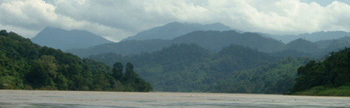
Rugged mountains covered by a large forest. These rugged mountains help maintain fertile forests which house plants and animals some of them are rare. The highest mountain is Doi Kham Phra at 1,794 metres from sea level.
Climate
The weather is quite hot in the summer but during cold season the lowest temperature is 7.5ºC average. The heaviest rain comes in August that brings strong winds and hailstorm.
Places to visit
- Yod Doi Tuay view point is located at the north of the park. You can view a landscape of Thailand and Myanmar from the top of Yod Doi Tuay.
- 45th km view point is located at 45th kilometres on Mae Cha - Peang Luang road. This area belongs to Khun Klong headwater rangers. On the top you can have a view of Doi Chiang Dao wildlife sanctuary.
- Pang Tong waterfall is a medium waterfall that is hidden by the forest. The water run underground for 50 - 60 metres and come out of a cavity to a cliff. The waterfall area is covered by evergreen forest.
Accommodations and facilities
There are two bungalows for rent.
Contact address
Pha Daeng National Park
Muang Na sub district,Chaing Dao district
Chaing Mai 50170
Phone: 053-317 498, 053-261 466
|