|
National parks in the North
Doi Suthep - Doi Pui National Park
Click to the map
In 1981 Doi Suthep national park in Chiang Mai was registered as the country's 24th national park.
In the following year additional areas were annexed to the park, bringing the total area to 261 square kilometers.
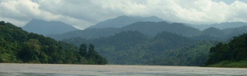
The topography of Doi Suthep is high mountains composed of many ridge systems. The prominent peaks are Doi Suthep, Doi Pui and Doi Buagha. Doi pui is the highest at 1,658 maters above sea level. The park serves as the source of headwaters for the Ping river tributaries.
The high topography of the park means that the climate is cool year round. The average temperature is 16ºC. Moist and cool air is indicative of the rainy season which peaks in August and September. In February, the air is crisp and clear and the landscape is sharply visible from the parks viewpoints.
Hill evergreen, dry dipterocarp, mixed deciduous, and pine forest are all represented in Doi Suthep.
Deer, monkeys, macaques and over 200 kinds of bird species are found, including cagles, jungle fowl, orioles, woodpeckers, and drongos.
Tourist attractions
- Phu Ping Ratchanivej palace: This beautiful palace serves as a vacation home for the King and Queen and the royal family. The palace was built in 1960 in thai architecture. Within the ground, the original landscaping has been preserved as much as possible while planting various species of flowers. The palace is located 4 km from the park headquarters and is open the public on Fridays and public holidays.
- Phrathat Doi Suthep temple: This temple, built in 1384, is important both for its sacredness and for its historical role in Chiang Mai. The stairway, with more than 300 steps, is bordered by two long Nagas or snakes. In the temple are stored some of the ashes of The Lord Buddha. The full name of the temple is "Wat Prabraromatad Doi Suthep Worawihan". This sacred temple, decorated in The Lanna Style, is frequented by worshippers.
- Phra Kru Ba Siwichai memorial: In 1934, Phra Kru Ba Siwichai, a famous monk instructor staying at Sisoda Temple, led a drive to build a 12 km road from the base of mountain to Phrathat Doi Suthep temple. The road was completed in six months. Later the citizens of Chiang Mai built a memorial to Phra Kru Ba Siwichai, so that people could continue to pay him respect.
- Huay Kaeo waterfall: Located near the top of Doi Suthep, this waterfall is fed by the Huay Kaeo stream.
- Monta Tan waterfall: Located 3 km from Huay Kaeo waterfall, this impressive waterfall tumbles down in 3 stages over a high cliff face. It is also called Sanpayang waterfall.
- Mae Sa waterfall: The combination of 8 falls separated by distances of 100 to 500 meters. From Chiang Mai, travel north on the Chiang Mai - Mae Rim road (route 107) and Mae Rim - Samoeng road (route 1096). You will find turn off road to the left (south) to Mae Sa waterfall. Other waterfalls are found along the same stream, including Palad and Paw Paw Paw. Further away are Sisangwan, Mahidol, Tadmawg-Wanghang and Tad Mok fa waterfalls.
- In addition to these spots, there are many other interesting places, which include Pangub cliff, Palad cliff, Padam cliff, the peak of Doi Pui and hilltribe villages.
Accomodations and facilities
In the headquarters area there are several bungalow houses available for rent, one house
near Monta Tan waterfall ranger station and one youth hostel near Mok Fa waterfall are available.
Several camping grounds with car parking, rest rooms and food stalls are in the park. Four
visitor centers serve as information providers. Please contact the park for a map and
directions.
How to get there
Go by public transportation 16 km along the Hueygaow road until you reach Phrathat
Doi Suthep temple. Just a little way past the temple on the right hand side of the road
there is a sign which indicates the way to the park office.
Contact address
Doi Suthep National park,
Huai Kaew road, Suthep Sub-district, Amphur Muang Chiang Mai, Chiang Mai, Thailand 50200
Phone: 053-210 244
|