|
Inle Lake and Mrauk U (northern Rakhine state)
|
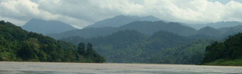
Inle Lake
Click here to view the map
Traveling information
Inle lake is located in the southern Shan state. Nearby tourist places are Kalaw, Pindaya and Taunggyi (the capital of Shan state).
There are highway buses linking Inle lake area with Bagan, Mandalay and Yangon. The approximate distances are:
to Yangon = 700 km (there are overnight buses)
to Bagan = 301 km
to Mandalay = 309 km
 Tourists can also take train to Shwe Nyaung (north of Inle lake) station from where it is a 20 min drive to Nyaung Shwe (the town close to the lake).
By flight, tourists can come to Heho and then continue by road to the lake. Air Mandalay, Yangon Airways and Myanmar Airways fly to Heho daily. There are several hotels on and near the lake. Kalaw, Pindaya, Taunggyi also have guesthouses and hotels. Some hotels offer car and boat rental services plus tours and hiking to the tribe villages.
Tourists can also take train to Shwe Nyaung (north of Inle lake) station from where it is a 20 min drive to Nyaung Shwe (the town close to the lake).
By flight, tourists can come to Heho and then continue by road to the lake. Air Mandalay, Yangon Airways and Myanmar Airways fly to Heho daily. There are several hotels on and near the lake. Kalaw, Pindaya, Taunggyi also have guesthouses and hotels. Some hotels offer car and boat rental services plus tours and hiking to the tribe villages.
The lake is roughly 14 km in length, north to south, and the elevation of its water surface is 900 meters above the sea level. It is believed that the size of the lake is smaller each year. One reason is the less rain falls as a result of deforestation on the surrounding mountains.
Late February to early May are hottest months, day time temperature could go up to 35ºC. November to January are coldest with average 8ºC. Rain usually starts in May and ends in October, with the heaviest fall in July and August.
People
Local Inle lake people (Inthar) are close relatives of Bamar (Myanmar's main race) people. They speak and write almost the same language as Bamars. There are diferent theories about how and when these people came to the Inle lake.
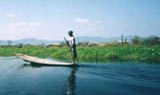
They are probably the only people in the world who have successfully settled their life on water - houses, vagetable and fruit gardens, markets and temples all right on the water. They can row their boats with one leg while standing on the other leg.
Their floating islands are naturally made of a mixture of mud, weeds and grass. Lake people cut these masses into strips of about 200 feet by 12 feet. These strips of floating masses are moved to a desired location and then anchored to the lake bed using the long bamboo poles.
The lake is generally shallow. Now nearly one third of the lake surface is covered by these floating islands on which are gardens of flowers, vegetables, beans, fruits and also the huts to stay.
They also grow rice in the areas along the lake banks. Fishing is one of the main sources of food for local people as well as those in the nearby towns and villages surrounding the lake.
The strange thing which is very obvious is that the people living on the hills surrounding the lake are the tribes with completely different languages and traditions from the lake people.
In 2001 there were 64 villages with a total population of over 80,000 people living in the lake.
Handicrafts, carpentry and boat building
Each village usually have a smith who produce and repair metal tools such as knives, axes, shovels, ploughs, mattocks.
In few villages (Ywa Ma village - main village) there are silverware makers. The design and style of the products are different from a village to another.
The lake people are good at carpentry and boat building. They build their houses, furniture, carts and other items for their own use.
Boats as large as 150 feet long are built and used on the lake. Long boats for the racing can take 100 men standing in two rows.
Mwe Puey village is where tourists can visit the boat builders. Naturally there are boat builders in several other villages too.
With the tourim starting to boom, tourist boats with engines are being built. Engines are imported from China and Thailand.
In the old days lake people used boats dug out from the huge teak trunks. You can still see some of these canoe-like boats today.
Goods and bads
With the tourists flocking into this tiny community of unique culture, it is very urgently necessary to plan a good plan to avoid major problems.
Money flows in together with the tourists, which is a good thing to grab. With the higher income people can buy things they want.
However there are bad things too. With so poor in every good thing including the physical and mental health of its citizens, Myanmar has started to swallow a complexity of social and cultural problems that have already been eaten (to the near-full) in other south east Asian countries.
We will just talk about a few things here:
Historical artifacts - With more and more visitors coming to the lake many of the manusctipts (especially those with illustrations) are being bought and taken away by collectors and foreign researchers. Now it is very important for the Myanmar government (Universties and related organizations) to do proper database and research of its own. Foreign tourists should not buy any historical items from anyone.
Leg rowing - With the arrival of motor boats it is likely that in the future there may be not many local people who can row their boats with one leg. Art of leg rowing may vanish altogether in the future.
Environment - The lake itself is silting up fast and needs rapid environmental protection to control the shrinking waters. More trees need to be planted along the mountain ranges. Use of clean energy such as wind and solar must be supported and financed by the government and organizations.
The birds, fishes, and animals also need protection too. Plastics and other garbage problems must also be solved properly.
|
|
Mrauk U - northern Rakhine state
Click here to view the map
Until 1990's northern Rakhine state was a place seldom visited by foreign visitors due to the lack of good transportation, communication and accommodations.
Now there are flights between Yangon and Sittwe (capital of Rakhine state). However they fly only 3 or 4 days aweek. So please check with a travel agent for the actual flight schedule.
 Mrauk U (Mrauk Oo) is still another 64 km away from Sittwe which is best done by boat along Kaladan river (Kitsapanadi) and Lay Myo river. Driving is still not an option for foreign tourists. Even there are progress in building roads and bridges it is still not possible for foreigners to travel to northern Rakhine state by car.
There is a daily boat service between Sittwe and Mrauk U (Mrauk Oo). The boats are run by Myanmar inland water transport corporation. Normally the boats are double deckers with common hall and private cabins. There are common toilets onboard.
The boat leaves Sittwe early morning and arrives Mrauk U about mid-day. Return boat is in the afternoon. Between Sittwe and Kyauk Taw there are boats 4 days aweek. Again, please check with a local travel agent for the actual time table. Smaller boats are available for charter.
The hottest month is April with average temperature of 34ºC. The coldest month is January with average 16ºC. The area receives rains from early June till October with the heaviest falls in July and August. In Mrauk U and Kyauk Taw the cool season's night temperature could be quite low.
Sittwe
Sittwe became an earliest sea port under the British colonial rule in 1828. During the second world war, it was heavily bombed by allied forces and the town was totally flatten.
Farkir point (the long black sand sea beach) is a lovely place which offers good views including sunset scenes, frech sea breeze, and a place to walk.
There are 3 or 4 pagodas worth visiting, and the Rakhine state cultural museum and library showcasing many ancient artifacts, silver coins, inscriptions and sculptures.
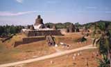
Mrauk U
Between 1430 and 1785 it was the last capital of Rakhine kings, where the Rakhine culture had its full bloom.
Founded in 1430, the city was fortified with 19 miles (30 km) long walls, moats and natural barriers. At the center of the city was the royal palace. There are several massive temples constructed in the stone cave structures. Most of these temples house array of lord Buddha images and artifacts of the past.
It is advised to spend about 3 days to visit important monuments in Mrauk U area alone.
After the annexation of Rakhine state by the British, the capital was moved to Sittwe. Since that time time Mrauk U was being known as Old City (Myo Haung) until 1979.
Cities before Mrauk U
Vesali: -
Today ruins of the last Vesali city is located 8 km north of Mrauk U. Vseali was believed to be ruled by kinds of local dynasties till 3325 B.C. The next rising of Vesali was after the end of Dhanyawaddy in 350 to 370 A.D. (note the years are still under the debate). The end of this second (here please do not pay attention to the word "second" - it may not be true) Vesali was believed to happen at the end of 8th century. It is also the start of Lemro (Lay-myo river) kings era.
Ruins of Vesali contains the city walls, mounds, cemetry hill, city gate pagoda, synod hill (the great image of Vesali & Buddhist synod hill), etc. The old palace site is now serving as settlement of Waythali (Waythali and Vesali refer to the same name) village.
Dhanyawaddy: -
Dhanyawaddy is located 10 km east of Kaladan river (now called Kitsapanadi river), and 26 km north of Vesali.
Speaking about the years, it is possible that the first city of Dhanyawaddy was founded at the end of first Vesali (around 3325 B.C).
The end of the last Dhanyawaddy was suggested to be in 350 or 370 A.D. (please see above "Vesali").
Dhanyawaddy was built on the flood plains of Kaladan river valley. The ruins of the city walls, moats and other structures can be seen. Old pagodas such as Mahamuni shrine, Kyauk taw pagoda (10 km west of Dhanyawaddy, on the western bank of Kaladan river), pagodas on Salagiri hills (opposite Kyauk taw, on the eastern bank of Kaladan river) can be visited.
Kyauk taw: -
is located on the western side of Kaladan river, opposite Salagari hill. Old stone pillar inscription and many other old artifacts are found in the monasteries of the town.
Sittwe (capital of Rakhine) is 120 km down Kaladan river.
Lemro dynasty: -
Dynastries that follow at the end of Vesali (end of 8th century) settled their capitals along Lemro (Lay-myo) river.
The end of Lemro dynasty was brought about in the early 15th century (before Mrauk U era).
There are ruins of 4 cities along the river.
Laungret is located 8 km east of Mrauk U, on the western bank of Lay-myo river. Only little are left to be seen today.
Parein is located just north of Laungret. There are little to see of the past.
Pyinsa is situated to the east of Mrauk U. Only some odd looking ponds are left.
Nareinsara Toungoo is said to have existed on the eastern side of river, opposite Pyinsa.
|
|