|
|
National parks in the North
Nam Nao National Park
Click here to go to the map
Nam Nao is one of Thailand's most beautiful parks. It covers an area within Lom Sak and Lom Kow districts in Phetchabun province, and Kornsan district within Chaiyaphum province.
The park covers a total area of about 966 square kilometers. The park was designated on the 26 September 1982.
Topography
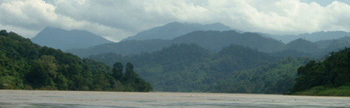
It is part of the Phtchabun mountain range running through Chaiyaphum and Phetchabun provinces. Phu Phachit mountain is the tallest in the park and topography is comprised of evergreen forest and streams.
The park is in an unusual and fascinating landscape with deciduous forest dominated by tall pine trees.
Climate
The daytime temperature are very pleasant with an average annual temperature of 25ºC. Cold season can be very cold, sometimes near 0ºC at night time during December - January.
Flora and fauna
The forest of Nam Nao contains many different forest types including dry dipterocarp, deciduous, evergreen, hill evergreen and pine forest. The open, dry deciduous forest of Nam Nao has a lush ground cover of grasses which, together with the park's perennial streams, salt licks and patches of evergreen forest, provide a rich and diverse habitat for the wildlife.
Wildlife that are believed to be surviving are tiger, leopard , banteng, deer, barking deer, a siatic black bear, malaysian sun bear, fox, porcupine, wild pig, guar, mouse deer and rabbits. There are over 130 species of birds in the park.
Tourist attractions
Phu Kor view point: In the cold season this is a good place to watch the sunrise, and from here you can see Phukradung national park and also Phu Pa Jit mountain within Nam Nao national park. There is a trail from the visitor center to this view point.
Tam Par Hong view point: From the road walk 300 meters to the view point where you will be rewarded with a good view. Walk a further 200 meters to a spot which is particularly good for watching the sunset.
Suan Son Ban park: This area has a large pine forest and grassland. There is a nature trail in the area.
Suan Son Phu Goom Kow: This area of tall pine trees as tall as 30 to 40 meters, covers an area of about 10 square kilometers.
Phu Goom Kow: A hill pleateu of about 880 meters above sea level. From this hill people can see Chulabhorn reservoir formed by the dam.
Heaw Sai waterfall: A 20 meters high fall. The water comes from Sa Nam sai stream. This forms a natural border between Nam Nao and Khonsan districts.
Phu Pha Jit: The 1,271 meters high flat top mountain needs 6 to 7 hours hike to reach. The trail from the highway no. 12 (km mark 67) to the peak is a steep 7 km path.
There are limestone hills with good view points, caves and waterfalls in the park.
How to get there
Park's headquarters is located 55 km east of Lomsak and 103 km west of Khon Kaen, on highway no. 12. There are buses from both Lomsak and Khon Kaen for the park.
Facilities
The Park has 10 bungalows ranging in size from 8 to 30 people. Tents are available for rent. There is a park restaurant.
Contact address
Nam Nao National Park,
Lom Sak district,
Phetchabun 67110
Tell: 056-729 002
|
|