|
|
Marine National Parks
Surin Island Group National Park
Maps |
Bungalows
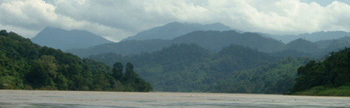
Koh Surin national park was gazetted on 29 July 1981 covering an area of 135 square kilometers just a few km south of Thailand-Myanmar border on Andaman sea.
About 76% of the total area is sea, and rest are islands - there are 5 main islands in the park. Koh Surin Nua (north island), Koh Surin tai (south island) are the two largest islands; other three being Koh Ree (or Koh Satok), Koh Glang (or Koh Pachumba), and Koh Khai (or Koh Torinla).
Koh Surin islands are roughly 60 km to the west of Phang Nga coast, and about 100 km to the north of Koh Similan islands.
These islands have been a refuge for the fishing boats during rough weather, as well as home for the sea gypsies.
Marine environment
Since these islands are located at deep sea far from the mainland, the environment is quite clean and almost pollution-free. The islands are covered by healthy forest and thus the amount of eroded materials entering the sea is minimum. Visibility in the water is very good.
Coral growth is healthy especially in the sheltered bays on the eastern sides of the islands. The sea around the islands are also rich in marine life. In addition to the hard and soft corals there are sea feathers, star fish, spiny lobster, giant clam and so on. Fish species found around the reefs are parrot fish, clown fish, black tip shark, lion fish, angel fish, etc.
Terristrial environment
Three different types of forest cover the islands. From the coast up to the peaks of hills, tropical evergreen forest are found. Along the beaches of the larger islands there are beach forest. In the more sheltered areas and around the mouths of rivers where the water is brackish, mangrive forests exist.
Attractions
Mu Ko Surin principal attraction is the fact that it is an upspoilt tropical paradise far from the mainland, with healthy forested islands surrounded by clean water supporting a world of marine life.
Each year many visitors visit the island grops. Some come in ferryboats, while the others come in chartered boats with equipment for diving, snorkeling and so on.
Sea gypsies or Morgan are a nomadic sea people inhabiting islands from India to Indonesia. The name Morgan is derived from their language which is universal to all sea gypsy groups. Sea gypsies live a very primitive existence and as such have a great respect for nature and the environment. They rely upon their environment for food, clothing and for the materials for boat construction. They live by spear fishing and collecting shellfish. Being nomadic they spend a lot of their time travelling, but they avoid travelling during the monsoon season from May to November. During this time they moor their boats in a sheltered location to form a temporary village of several families. These villages then break up when they start travelling again in December until April. The sea gypsies do not have a written language, but many of them can speak Thai and Yawi Malaysian. Every year during April an important ceremony is arranged on Koh Surin. Many sea gypsies from other islands come to attend the ceremony.
They often come from as far away as Myanmar and the islands of peninsula Thailand and Malaysia. The festival is called "Loi Reua" and involves ancestor worship. During the ceremony the spirits of the deads are asked to care for and protect the sea gypsies.
How to get there
The islands are located in the Andaman sea off shore from Phangnga province in southern Thailand. A ferry runs from Kuraburi to the islands. The dock jetty is 6 km north of Kuraburi town, on the highway no. 4 between Takua Pa and Kapoe. The ferry takes around 4 hrs to the islands.
Accommodations and facilities
Mu Ko Surin national park has several bungalows which should be booked well advance either at the park
shore station (Phone: 076-491 378) in Kura Buri or Royal Forest department in Bangkok.
|
|